AP Human Geography

AP Human Geography

AP Human Geography

AP Human Geography

AP Human Geography.Introduction: In a world shaped by interconnectedness, diversity, and constant change, the study of human geography emerges as a captivating field that seeks to unravel the complexities of human societies and their relationship with the environment. AP Human Geography, a rigorous course offered to high school students, provides a comprehensive exploration of this dynamic discipline. Through examining patterns, processes, and phenomena, this blog delves into the fascinating realm of AP Human Geography, shedding light on its key concepts, significance, and real-world applications.

AP Human Geography. Defining AP Human Geography

Defining AP Human Geography: AP Human Geography is a college-level course that introduces students to the systematic study of patterns and processes which shapes human societies. It encompasses the examination of topics such as population, migration, culture, political organization, urbanization, and the environment. By understanding these spatial relationships, students develop critical thinking skills and gain insights into how humans interact with their surroundings.

AP Human Geography The Importance of AP Human Geography

AP Human Geography Understanding Global Interconnectedness: In an era of increasing globalization, AP Human Geography equips students with the knowledge to comprehend the complex web of interactions between people, places, and resources on a global scale. It encourages a broader perspective, fostering cultural competence and empathy for diverse societies.

Shaping Policy and Decision-Making: Human geography plays a crucial role in informing policy and decision-making processes at various levels, including local, national, and global. AP Human Geography nurtures analytical thinking and spatial awareness, empowering students to contribute to sustainable development, urban planning, and social justice initiatives.

Key Concepts Explored in AP Human Geography

Population and Migration: The study of population dynamics, including birth rates, death rates, and migration patterns, offers insights into demographic transitions and their impacts on societies. Understanding migration helps explain the causes and consequences of human mobility, including economic, social, and environmental factors.

Cultural Patterns and Processes: Cultural geography explores the diffusion, assimilation, and preservation of cultures. Topics such as language, religion, ethnicity, and popular culture shed light on how identities are formed and transformed, and how cultural landscapes evolve over time.

Political Organization of Space: Examining political systems, international relations, and the spatial distribution of power helps students understand geopolitics, territoriality, and the complexities of governance. AP Human Geography explores topics such as state formation, boundary disputes, and the impact of globalization on sovereignty.

Urban Geography: With rapid urbanization being a defining trend of the 21st century, AP Human Geography delves into the study of cities and urban processes. It examines the social, economic, and environmental challenges associated with urban growth, including issues like housing, transportation, and urban planning.

Real-World Applications

Sustainable Development: AP Human Geography fosters an understanding of the interplay between human activities and the environment. This knowledge is essential for promoting sustainable development practices, including managing resources, mitigating climate change impacts, and creating resilient communities.

Social Justice and Equity: By examining patterns of inequality, including disparities in wealth, access to resources, and social opportunities, AP Human Geography encourages students to critically analyze social justice issues. This understanding can inform efforts to address systemic inequities and promote inclusive societies.

Career Opportunities: AP Human Geography opens up a wide range of career paths, including urban planning, international relations, environmental management, market research, and social advocacy. The skills developed in this course, such as data analysis, critical thinking, and spatial reasoning, are highly valued in various professions.

Conclusion: AP Human Geography serves as a window into the intricate tapestry of human societies, their interactions, and the environment. Through its exploration of population.

AP Human Geography curriculum / Course Content

The AP Human Geography curriculum offers students an in-depth exploration of the various facets of human geography. Here are some key points regarding the curriculum:

Course Content

  • Unit 1: Thinking Geographically
  • Unit 2: Population and Migration Patterns and Processes
  • Unit 3: Cultural Patterns and Processes
  • Unit 4: Political Patterns and Processes
  • Unit 5: Agriculture and Rural Land-Use Patterns and Processes
  • Unit 6: Cities and Urban Land-Use Patterns and Processes
  • Unit 7: Industrial and Economic Development Patterns and Processes

Unit 1: Thinking Geographically

You’ll learn about the tools and methods geographers use in their study of places.

Topics may include:

  • Different types of maps and what they tell you
  • How geographers collect and use data
  • Spatial relationships and patterns
  • Data analysis at different scales (for example, global, national, local)
  • How geographers define regions

On The Exam

8%–10% of multiple-choice score

Unit 2: Population and Migration Patterns and Processes

You’ll explore the patterns associated with human populations.

Topics may include:

  • Population density and how it affects society and the environment
  • Theories of population growth and decline
  • Population and immigration policies and their effects
  • The causes and effects of migration

On The Exam

12%–17% of multiple-choice score

Unit 3: Cultural Patterns and Processes

You’ll focus on how and why language, religion, and other cultural practices spread over space and time.

Topics may include:

  • The different ways that cultural practices spread
  • Historical forces, such as colonialism and trade, that affect cultural patterns
  • Modern forces, such as globalization, that affect cultural patterns
  • Why different religions spread in different ways

On The Exam

12%–17% of multiple-choice score

Unit 4: Political Patterns and Processes

You’ll build on your knowledge of populations and cultural patterns as you learn about the political organization of the world.

Topics may include:

  • Types of political entities such as nations and nation-states
  • The ideas and forces that shaped the political boundaries of the modern world
  • Forms of government such as unitary states and federal states
  • The factors that lead to states breaking apart

On The Exam

12%–17% of multiple-choice score

Unit 5: Agriculture and Rural Land-Use Patterns and Processes

You’ll learn where humans first developed agriculture and how farming practices spread throughout the world.

Topics may include:

  • How physical geography influences farming practices
  • The origins and spread of agriculture
  • The Green Revolution
  • How farming practices affect the environment and society

On The Exam

12%–17% of multiple-choice score

Unit 6: Cities and Urban Land-Use Patterns and Processes

You’ll explore the origins and influences of urbanization, examining cities across the world and the role of those cities in globalization.

Topics may include:

  • The factors that drive the growth of cities and suburbs
  • Globalization and cities
  • City infrastructure
  • Urban design initiatives and practices

On The Exam

12%–17% of multiple-choice score

Unit 7: Industrial and Economic Development Patterns and Processes

You’ll study the origins and influences of industrialization, along with the role industrialization plays in economic development.

Topics may include:

  • The Industrial Revolution
  • Economic sectors and patterns
  • How economic development affects the roles of women
  • Trade and the world economy

On The Exam

12%–17% of multiple-choice score

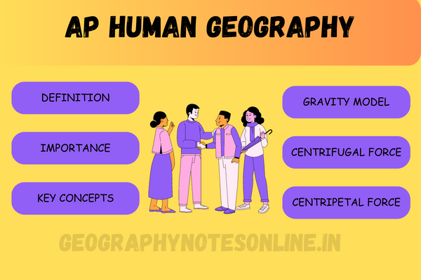
Gravity Model AP Human Geography

The gravity model is a fundamental concept in AP Human Geography that explains the movement of people, goods, and ideas between different locations. By considering the size of locations and the distances between them, this model provides insights into migration patterns, trade flows, and transportation networks, aiding in the understanding of spatial interactions and their implications.

Centripetal Force AP Human Geography

Centripetal force, in the context of AP Human Geography, refers to factors that promote unity, stability, and cohesion within a country or region. It encompasses social, political, economic, and cultural forces that bind people together. Examples of centripetal forces include a common language, shared cultural traditions, effective governance, economic interdependence, and the presence of national symbols and institutions. Centripetal forces help maintain territorial integrity, foster national identity, and promote social harmony. However, in some cases, they can also lead to the suppression of minority groups and cultural diversity. Understanding centripetal forces is crucial for analyzing the dynamics of nation-states and regional integration processes.

Centrifugal Force AP Human Geography

Centrifugal force, in AP Human Geography, refers to factors that destabilize, divide, or weaken a country or region. These forces can be social, cultural, political, or economic in nature. Examples of centrifugal forces include ethnic or religious conflicts, linguistic divisions, economic disparities, political dissent, and regional autonomy movements. Centrifugal forces tend to challenge the unity and cohesion of a nation-state, often leading to separatism, secession, or even the breakup of countries. Understanding centrifugal forces is essential for analyzing the dynamics of regionalism, ethnonationalism, and the potential for political fragmentation within a country or region.

Assimilation AP Human Geography

Assimilation, in the context of AP Human Geography, refers to the process by which individuals or groups adopt the cultural traits, language, and values of the dominant society. It involves the integration of minority or immigrant populations into the larger cultural framework. Assimilation can occur voluntarily or through social and political pressures. It often leads to the loss of distinctive cultural practices, languages, and identities as individuals conform to the dominant culture. Assimilation has both positive and negative impacts, as it can promote social cohesion and reduce social tensions, but it can also contribute to the erasure of cultural diversity and the marginalization of minority groups.

Cultural Landscape AP Human Geography

Cultural landscape, in the realm of AP Human Geography, refers to the visible imprint of human activity on the physical environment. It encompasses the built environment, natural features, and symbolic elements that reflect the cultural practices, beliefs, and values of a particular society. Cultural landscapes can range from urban areas with architectural landmarks and infrastructure to rural regions with agricultural patterns, religious sites, or indigenous settlements. Studying cultural landscapes provides insights into how humans shape and interact with their surroundings, and how these landscapes evolve over time. They serve as tangible expressions of cultural identity, heritage, and the complex relationship between humans and the environment.

Agglomeration AP Human Geography

Agglomeration, in AP Human Geography, refers to the concentration of economic activities and industries in specific locations. It occurs when related businesses cluster together to take advantage of shared resources, labor pools, infrastructure, and knowledge exchange. Agglomeration can lead to increased productivity, innovation, and economies of scale. It promotes efficiency through reduced transportation costs, easier access to suppliers and customers, and the formation of specialized labor markets. Examples of agglomeration include technology hubs like Silicon Valley, financial centers like Wall Street, and industrial clusters like automotive manufacturing regions. Understanding agglomeration helps explain patterns of economic development, urban growth, and regional specialization.

What is Human Geography ?

Human geography is the study of how people interact with and shape their environment. It explores the spatial patterns and processes of human activities, including population distribution, cultural practices, economic systems, political organization, and their impact on the world.

Is Human Geography a Social Science?

Yes, human geography is considered a social science. It falls within the broader field of geography, which encompasses both physical geography (the study of the natural environment) and human geography (the study of human activities and their relationship with the environment). As a social science, human geography focuses on the social, cultural, economic, and political aspects of human societies and their spatial patterns and processes. It employs methodologies and theories from disciplines such as sociology, anthropology, economics, and political science to understand and explain human behavior, interactions, and the organization of societies in relation to their geographic context.

Situation AP Human Geography

Situation, in AP Human Geography, refers to the location of a place in relation to its surrounding environment and other places. It considers both the physical and cultural characteristics that impact a place’s connectivity, accessibility, and interactions with other locations, influencing its economic, social, and political dynamics.
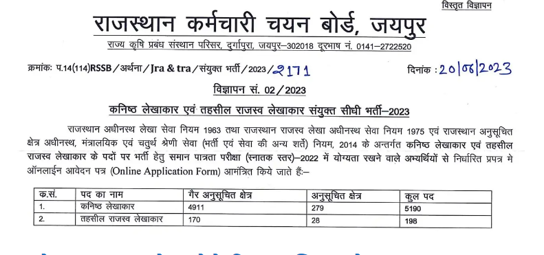

Also Read

jet stream

(PDF) Jet Stream | Jet Stream and its types

Jet Stream

Jet Stream | Jet Stream and its types

Jet Stream | Jet Stream and its types.Jet Stream Jet stream – These are very high speed horizontal winds running from west to east near the troposphere. It remains active in the form of a transition belt 150 km wide and 2 to 3 km thick. Their speed is 150 to 200 km per hour. Their speed on core can be up to 325 km per hour.

Jet streams are generally found only in the Northern Hemisphere and in the Southern Hemisphere they are found only at the South Pole. They run from west to east. The main reason for their origin is the difference in temperature on the surface of the earth and the pressure gradient generated from it. The main reason is the thermal gradient generated between the equatorial region and the polar region. Due to the higher thermal gradient in winter than in summer, the intensity of jet stream also increases in winter.

Due to the absence of terrestrial surface in the Southern Hemisphere, the temperature gradient is less, so the jet stream is less stable in the Southern Hemisphere and more stable in the Northern Hemisphere.

Due to the decrease in the height of the troposphere from the equator towards the poles, there is also a decrease in the height of the jet stream.

Jet Stream | types of jet stream

  1. polar night jet stream
  2. polar front jet stream
  3. subtropical jet stream
  4. tropical easterly jet stream

Polar Night Jet Stream

They are found in latitudes above 60 degrees in both the hemispheres.

Polar Front Jet Stream

It is found at an altitude of 9 to 12 km between 40-60 degrees northern latitudes. It is related to the polar air masses. These waves follow the said anomalous path. Their speed is 150-300 km per hour, and air pressure is 200 to 300 millibars. These are also called Rossby waves.

Subtropical Jet Stream

They are found at an altitude of 10 to 14 km between 30 to 35 degrees north latitudes. Their speed is 350 to 385, and air pressure is 200 to 300 millibars. The main reason for their origin is the convection action due to high temperature in the equatorial region. These jet winds are responsible for the Western Disturbances in India between December and February.

Tropical Easterly Jet Stream

Unlike other jet streams, its direction is northeast. They only occur in the summer in the Northern Hemisphere, near 25 degrees north latitude. At an altitude of 14 to 16 km, they originate in areas with 100 to 150 millibar air pressure. Their speed is 180 km per hour. This jet is responsible for the origin of the Indian monsoon.


Also Read

The Pacific Ring of Fire

The Pacific Ring of Fire

The Pacific Ring of Fire

The Pacific Ring of Fire || Andesite line

The Pacific Ring of Fire, a region encircling the Pacific Ocean, holds a fiery reputation as one of the most geologically active areas on Earth. This vast arc stretches for approximately 40,000 kilometers and is home to about 75% of the world’s active volcanoes. In this blog, we will embark on a journey into the awe-inspiring realm of the Pacific Ring of Fire, exploring its geological wonders, volcanic activity, and seismic forces that shape our planet.

Understanding the Tectonic Dance:

The Pacific Ring of Fire owes its existence to the interactions between several tectonic plates that converge along its boundaries. The boundaries primarily consist of subduction zones, where one tectonic plate slides beneath another. These subduction zones are responsible for the creation of volcanic arcs, mountain ranges, and deep ocean trenches, making the Pacific Ring of Fire a geological hotspot.

Volcanic Splendor:

The Pacific Ring of Fire boasts an impressive array of volcanoes, both active and dormant. From Mount Fuji in Japan to Mount Rainier in the United States, these towering giants punctuate the landscape with their majesty. The volcanic eruptions in this region not only create breathtaking sights but also contribute to the formation of new landmasses and release gases and minerals that enrich the Earth’s crust.

The Fury of Earthquakes:

Along with volcanoes, the Pacific Ring of Fire is renowned for its seismic activity. The collision and subduction of tectonic plates lead to intense pressure and strain, resulting in frequent earthquakes. Major fault lines, such as the San Andreas Fault in California and the Great Sumatra Fault, traverse the region, making it vulnerable to powerful seismic events that can have significant societal and environmental impacts.

Submarine Mysteries:

Beneath the Pacific Ocean’s surface lies a hidden world of undersea volcanoes, hydrothermal vents, and submerged mountain ranges. These submarine features contribute to the unique geography of the Ring of Fire and support diverse ecosystems teeming with marine life. Exploring these underwater realms not only expands our knowledge of Earth’s geology but also uncovers fascinating species and ecological interactions.

Impacts on Human Settlements:

The Pacific Ring of Fire’s dynamic geology has significant implications for human settlements in the region. The frequent volcanic eruptions, earthquakes, and tsunamis pose challenges and risks to communities residing along the Ring of Fire’s coastlines. However, these challenges have also fostered resilience and adaptation among the people who call this region home.

Conclusion:

The Pacific Ring of Fire stands as a testament to the raw power and geological beauty of our planet. From the fiery eruptions of volcanoes to the rumbling tectonic shifts that shape landscapes, this region offers a glimpse into Earth’s dynamic nature. While the Pacific Ring of Fire presents challenges and risks, it also presents unique opportunities for scientific research, natural resource exploration, and the marvel of nature’s creative forces. As we continue to study and understand this magnificent geological theater, we gain a deeper appreciation for the interconnectedness of Earth’s processes and the delicate balance of life on our planet.


Also Read

Western Disturbances

Western Disturbances | पश्चिमी विक्षोभ

Western Disturbances

Western Disturbances | पश्चिमी विक्षोभ

Western Disturbances. पश्चिमी विक्षोभ भूमध्यसागरीय क्षेत्र में उत्पन्न होने वाला शीतोष्ण कटिबंधीय चक्रवातों से उत्पन्न वयुमंदालीय प्रणाली है ये तूफान जो अचानक सर्दी लाता है
भारतीय उपमहाद्वीप के उत्तर-पश्चिमी भागों में वर्षा को पश्चिमी विक्षोभ के रूप में जाना जाता है। यह एक वैश्विक जलवायु घटनाक्रम हैं
Western Disturbances.ये शीत काल में भूमध्यसागर में वायुदाब की पेटियों के दक्षिणी दिशा में स्थानांतरण के कारण पछुआ पवनो के दक्षिणी दिशा में स्थानातरण के कारण शीत काल में भारतीय उप महाद्वीप में प्रवेश करते हैं एवं शीतकाल में होने वाली वर्षा के लिए उत्तरदायी हैं |इनकी उत्पत्ति कास्पियन सागर एवं भू मध्य सागर में होती है |

Western Disturbances शीतोष्ण कटिबंधीय चक्रवात

Western Disturbances.ये चक्रवात शीत फ्रंट अथवा शीत वताग्र एवं उष्ण वताग्र के मिलन स्थल पर उष्ण एवं शीत वयुराशियों के मिलने से निर्मित होते हैं | ये पछुआ पवनों के प्रभाव के पश्चिम से पूर्व की और गति करते हैं | ये सम्पूर्ण यूरोप के मौसम को प्रभावित करते हैं |

Western Disturbances | जलवायु पर प्रभाव

  • यह निचले इलाकों में मध्यम से भारी बारिश और भारतीय उपमहाद्वीप के पहाड़ी क्षेत्रों में भारी मात्रा में बर्फ लाने में महत्वपूर्ण भूमिका निभाता है।
  • इनका आगमन आमतौर पर बादल छाए रहने, रात के उच्च तापमान और असामान्य बारिश के साथ होता है |
  • इनसे होने वाली मावठ वर्षा रबी की फसलों के लये बेहद लाभदायक है |
  • भारतीय गंगा के मैदान में ये शीत लहर के वाहक होते हैं |

Western Disturbances. मावठ

Western Disturbances. पश्चिमी विक्षोभ के कारण शीतकाल में होने वाली वर्षा मावठ कहलाती है |


EL NINO

EL NINO | एल नीनो

EL NINO

EL NINO | एल नीनो

EL NINO. परिचय: पृथ्वी की जलवायु को प्रभावित करने वाले असंख्य कारकों में से एक एल नीनो है। इस जलवायु संबंधी घटना ने वैज्ञानिकों, मौसम के प्रति उत्साही लोगों और आम जनता को समान रूप से वैश्विक मौसम पैटर्न पर इसके गहन प्रभाव के लिए आकर्षित किया है। इस ब्लॉग में, हम अल नीनो की आकर्षक दुनिया में तल्लीन होंगे, इसके कारणों, प्रभावों और हमारे ग्रह के प्रभावों की खोज करेंगे

एल नीनो एक गर्म जल की धारा है जो दक्षिणी अमेरिका के पश्चिमी तट पर उत्तर से दक्षिण की और पेरू की धरा के विपरीत प्रवाहित होती है | यह प्रशांत अहसागर के तापमान को बढ़ा देता है जिससे पूर्वी प्रशांत महासागर का उच्च वायुदाब निम्न वायुदाब में परिवर्तित हो जाता है । इसका समकक्ष, ला नीना, सामान्य वायुमंडल की दशा को दर्शाता है जिसमे पूर्वी प्रशांत का तापमान कम एवं बयुदाब उच्च रहता है |

एल नीनो के कारण

अल नीनो के कारण: अल नीनो समुद्र और वायुमंडल के बीच जटिल अंतःक्रिया से उत्पन्न होता है। सामान्य परिस्थितियों में, पूर्व से पश्चिम की ओर तेज़ व्यापारिक हवाएँ चलती हैं, जो सतह के गर्म पानी को पश्चिमी प्रशांत की ओर धकेलती हैं। हालांकि, एक एल नीनो घटना के दौरान, ये हवाएं कमजोर हो जाती हैं या उलट भी जाती हैं, जिससे गर्म पानी पूर्व की ओर पलायन कर जाता है, दक्षिण अमेरिकी तट के पास जमा हो जाता है।

अल नीनो का मौसम पर प्रभाव:

अल नीनो का मौसम पर प्रभाव: अल नीनो के दूरगामी परिणाम होते हैं, जो दुनिया भर में मौसम के मिजाज को प्रभावित करते हैं। इसके प्रभाव से दक्षिणी अमेरिका के तट पर बाढ़ , दक्षिणी एशिया महाद्वीप के विभिन्न क्षेत्रों में गंभीर सूखा और अन्य चरम मौसम की घटनाएं हो सकती हैं। उदाहरण के लिए, अल नीनो घटना के दौरान, दक्षिण अमेरिका के कुछ हिस्सों में अक्सर भारी वर्षा और बाढ़ का अनुभव होता है, जबकि ऑस्ट्रेलिया और दक्षिण पूर्व एशिया जैसे क्षेत्रों में सूखे की स्थिति का सामना करना पड़ सकता है।

वैश्विक प्रभाव:

वैश्विक प्रभाव: अल नीनो का प्रभाव स्थानीय मौसम पैटर्न से परे है। इसका प्रभाव मत्स्य पालन, कृषि को बाधित कर सकता है और यहां तक कि वैश्विक खाद्य कीमतों को भी प्रभावित कर सकता है। उदाहरण के लिए, समुद्र की धाराओं में बदलाव के कारण पेरू के तट पर मछली की आबादी में कमी तटीय समुदायों की आजीविका को प्रभावित कर सकती है जो मछली पकड़ने पर बहुत अधिक निर्भर हैं। इसके अतिरिक्त, वर्षा के परिवर्तित पैटर्न से फसल खराब हो सकती है, जिससे दुनिया के विभिन्न भागों में खाद्य उत्पादन प्रभावित हो सकता है। साथ ही यह भारतीय मानसून को कमजोर करती है |

एल नीनो और जलवायु परिवर्तन:

जबकि अल नीनो सदियों से एक प्राकृतिक जलवायु घटना रही है, इसकी आवृत्ति और तीव्रता पर जलवायु परिवर्तन के संभावित प्रभाव में वैज्ञानिक अनुसंधान जारी है। कुछ अध्ययनों से पता चलता है कि बढ़ते वैश्विक तापमान से भविष्य में अधिक बारंबार और मजबूत एल नीनो घटनाएं हो सकती हैं। संभावित जलवायु परिवर्तन की भविष्यवाणी करने और अनुकूलन करने के लिए इस संबंध को समझना महत्वपूर्ण है।

ला नीना

अल नीनो की छोटी बहन : ला नीना, अल नीनो-दक्षिणी दोलन (ENSO) चक्र के ठंडे चरण के अपने निहितार्थ हैं। यह आम तौर पर एल नीनो घटना का अनुसरण करता है और उष्णकटिबंधीय प्रशांत क्षेत्र में ठंडे-से-सामान्य समुद्र की सतह के तापमान की विशेषता है। ला नीना विपरीत प्रभाव ला सकता है, जैसे दक्षिण पूर्व एशिया और ऑस्ट्रेलिया के कुछ हिस्सों में बारिश में वृद्धि और अटलांटिक में तीव्र तूफान गतिविधि।

निष्कर्ष:


अल नीनो एक पेचीदा और प्रभावशाली जलवायु घटना बनी हुई है जो शोधकर्ताओं और जनता को समान रूप से आकर्षित करती है। इसके कारणों, प्रभावों और निहितार्थों को समझकर, हम पृथ्वी की जटिल जलवायु प्रणाली में मूल्यवान अंतर्दृष्टि प्राप्त कर सकते हैं। अल नीनो का चल रहा अध्ययन एक लचीले भविष्य के लिए अधिक प्रभावी जलवायु परिवर्तन अनुकूलन रणनीतियों में योगदान करते हुए, इसके प्रभावों का अनुमान लगाने और प्रतिक्रिया देने की हमारी क्षमता को बढ़ाने में महत्वपूर्ण भूमिका निभाता है।

एल नीनो क्या है इसका क्या प्रभाव है?

एल नीनो एक गर्म जल की धारा है जो दक्षिणी अमेरिका के पश्चिमी तट पर प्रवाहित होती है | यह प्रशांत महासागर के तापमान को बढ़ा देती है , मानसून को कमजोर कर देती है तथा दक्षिणी अमेरिका के पश्चिमी तट पर प्रचुर मात्रा में वर्षा होती है |

एल नीनो का दूसरा नाम क्या है?

एल नीनो का दूसरा नाम येशु शिशु है |

अल नीनो की खोज किसने की?

एल नीनो की खोज गिल्बर्ट वाकर और जे बरकनीज ने की |

एल नीनो का पर्यावरण पर क्या प्रभाव पड़ता है?

एल नीनो के कारणमानसून कमजोर पड़ जाता है |


AlsoRead

EL NINO

EL NINO UPSC | EL NINO NET GEOGRAPHY

EL NINO UPSC

EL NINO UPSC

EL NINO UPSC. Introduction: The Earth’s climate is a complex system influenced by a myriad of factors, one of which is El Niño. This climatic phenomenon has captivated scientists, weather enthusiasts, and the general public alike for its profound impact on global weather patterns. In this blog, we will delve into the fascinating world of El Niño, exploring its causes, effects, and implications for our planet.

el nino

el nino effect

el nino kya hai

el nino upsc

Understanding El Nino:

El Nino refers to a naturally occurring climate cycle characterized by warmer-than-normal sea surface temperatures in the tropical Pacific Ocean. It occurs irregularly, typically every 2 to 7 years, and can persist for several months to a couple of years. Its counterpart, La Niña, is characterized by cooler-than-normal sea surface temperatures.

Causes of El Nino

Causes of El Niño: El Niño originates from the complex interaction between the ocean and the atmosphere. Under normal conditions, strong trade winds blow from east to west, pushing warm surface waters toward the western Pacific. However, during an El Niño event, these winds weaken or even reverse, allowing the warm water to migrate eastward, piling up near the South American coast.

El Nino’s Impact on Weather

El Niño’s Impact on Weather: El Niño has far-reaching consequences, impacting weather patterns across the globe. Its influence can lead to severe droughts, floods, and other extreme weather events in different regions. For example, during an El Niño event, parts of South America often experience heavy rainfall and flooding, while areas such as Australia and Southeast Asia may face drought conditions.

Global Implications:

Global Implications: The effects of El Niño extend beyond local weather patterns. Its influence can disrupt fisheries, agriculture, and even affect global food prices. For instance, reduced fish populations due to changes in ocean currents can impact the livelihoods of coastal communities that heavily rely on fishing. Additionally, altered precipitation patterns can lead to crop failures, affecting food production in various parts of the world.

El Nino and Climate Change:

El Niño and Climate Change: While El Niño has been a natural climate phenomenon for centuries, there is ongoing scientific research into the potential influence of climate change on its frequency and intensity. Some studies suggest that rising global temperatures may lead to more frequent and stronger El Niño events in the future. Understanding this relationship is crucial for predicting and adapting to potential climate shifts.

El Niño’s “Cool” Cousin: La Niña:

El Niño’s “Cool” Cousin: La Nina: La Nina, the cold phase of the El Niño-Southern Oscillation (ENSO) cycle, has its own set of implications. It typically follows an El Niño event and is characterized by colder-than-normal sea surface temperatures in the tropical Pacific. La Niña can bring contrasting effects, such as increased rainfall in parts of Southeast Asia and Australia and intensified hurricane activity in the Atlantic.

Conclusion:

El Niño remains an intriguing and impactful climatic phenomenon that continues to captivate researchers and the public alike. By understanding its causes, effects, and implications, we can gain valuable insights into the Earth’s complex climate system. The ongoing study of El Niño plays a vital role in enhancing our ability to anticipate and respond to its effects, contributing to more effective climate change adaptation strategies for a resilient future.

एल नीनो क्या है इसका क्या प्रभाव है?

एल नीनो एक गर्म जल की धारा है जो दक्षिणी अमेरिका के पश्चिमी तट पर प्रवाहित होती है | यह प्रशांत महासागर के तापमान को बढ़ा देती है , मानसून को कमजोर कर देती है तथा दक्षिणी अमेरिका के पश्चिमी तट पर प्रचुर मात्रा में वर्षा होती है |

एल नीनो का दूसरा नाम क्या है?

एल नीनो का दूसरा नाम येशु शिशु है |

अल नीनो की खोज किसने की?

एल नीनो की खोज गिल्बर्ट वाकर और जे बरकनीज ने की |

एल नीनो का पर्यावरण पर क्या प्रभाव पड़ता है?

एल नीनो के कारणमानसून कमजोर पड़ जाता है |


Tornado Watch vs Tornado Warning

Tornado Watch vs Tornado Warning

Tornado Watch vs Tornado Warning

Tornado Watch vs Tornado Warning

Tornado Watch vs Tornado Warning: Understanding the Difference

Tornado Watch vs Tornado Warning. When severe weather strikes, it’s crucial to understand the difference between a tornado watch and a tornado warning. These terms are used by meteorologists to communicate the level of threat posed by tornadoes. In this blog post, we’ll explain the distinctions between a tornado watch and a tornado warning, helping you stay informed and take appropriate actions to stay safe.

US TORNADO WARNING WEBSITE https://www.tornadohq.com/

Tornado Watch:

  1. Meaning: A tornado watch indicates that weather conditions are conducive to tornado formation within the designated area and time period.
  2. Duration: Watches typically cover a large geographic area and can last several hours.
  3. Preparedness: During a watch, it’s important to remain vigilant and stay informed about the weather conditions. Keep an eye on weather forecasts, listen to local news or weather radio, and be ready to take shelter if necessary.
  4. Activities: Engage in monitoring weather updates, securing loose outdoor objects, and reviewing your family’s emergency plan.

Tornado Warning:

  1. Meaning: A tornado warning is issued when a tornado has been detected by radar or reported by spotters on the ground. It signifies an imminent threat to life and property.
  2. Duration: Warnings cover a smaller and more specific area, usually a county or part of a county. They are typically shorter in duration, ranging from a few minutes to an hour.
  3. Preparedness: When a warning is issued, immediate action is necessary. Seek shelter in a safe location, such as a basement, storm cellar, or an interior room on the lowest level of your home. Stay tuned to local news or weather updates for the latest information.
  4. Activities: Take shelter, ensure everyone is aware of the situation, and follow your emergency plan. Avoid windows and protect yourself by covering with a mattress or heavy blankets.

Conclusion:

Understanding the distinction between a tornado watch and a tornado warning is crucial for personal safety during severe weather events. A tornado watch implies that conditions are favorable for tornado formation, prompting vigilance and preparedness. In contrast, a tornado warning indicates an immediate threat and requires immediate action to seek shelter. By staying informed, having a plan in place, and following the guidance of local authorities, you can effectively protect yourself and your loved ones in the face of tornadoes. Stay safe!


Also Read

RPSC Assistant Professor Vacancy 2023

RPSC news

RPSC

RPSC

RPSC stands for the Rajasthan Public Service Commission. It is an autonomous body established by the Government of Rajasthan in India to conduct recruitment examinations and select candidates for various administrative positions in the state. The RPSC is responsible for conducting competitive exams for the recruitment of personnel in the Rajasthan Administrative Service (RAS), Rajasthan Police Service (RPS), Rajasthan Accounts Service (RAS), and other state government departments and offices.

RPSC news

The RPSC conducts examinations in a fair and transparent manner, adhering to the principles of merit, equal opportunity, and efficiency. It follows a structured selection process, which includes preliminary examinations, main examinations, and interviews, depending on the nature of the position. The commission also releases notifications, syllabi, and other important information related to the exams on its official website.

आरपीएससी योग्यता, समान अवसर और दक्षता के सिद्धांतों का पालन करते हुए निष्पक्ष और पारदर्शी तरीके से परीक्षा आयोजित करता है। यह एक संरचित चयन प्रक्रिया का अनुसरण करता है, जिसमें स्थिति की प्रकृति के आधार पर प्रारंभिक परीक्षा, मुख्य परीक्षा और साक्षात्कार शामिल हैं। आयोग अपनी आधिकारिक वेबसाइट पर परीक्षा से संबंधित अधिसूचना, पाठ्यक्रम और अन्य महत्वपूर्ण जानकारी भी जारी करता है।

RPSC news | Latest Update

आरपीएससी से सम्बंधित latest न्यूज़-

rpsc.rajasthan.gov.in admit card

आरपीएस सी से सम्बंधित भर्ती परीक्षाओं के admit card नीचे दिए गए लिंक से डाउनलोड किये जा सकते हैं – rpsc.rajasthan.gov.in admit card


Also Read

UGC NET JRF GEOGRAPHY PAPERS

UGC NET PREVIOUS YEAR CUT OFF MARKS

UGC NET PREVIOUS YEAR CUT OFF MARKS

UGC NET PREVIOUS YEAR CUT OFF MARKS
UGC NET JRF GEOGRAPHY PAPERS

UGC NET PREVIOUS YEAR CUT OFF MARKS.The UGC NET (National Eligibility Test) is conducted by the National Testing Agency (NTA) in India to determine the eligibility of candidates for the role of Assistant Professor and for Junior Research Fellowship (JRF). The cutoff marks for UGC NET are the minimum qualifying marks that candidates must secure to be considered for eligibility. The cutoff marks vary each year depending on factors such as the number of candidates, difficulty level of the exam, and overall performance.

It is important to note that the cutoff marks for UGC NET can differ across different subjects and categories (General, OBC, SC, ST, etc.). Candidates are advised to refer to the official notification or the NTA website for the specific cutoff marks of previous years.

UGC NET PREVIOUS YEAR 2022 CUT OFF MARKS Geography 2022

UGC NET PREVIOUS YEAR CUT OFF MARKS for Geography subject is given below

UGC NET PREVIOUS YEAR CUT OFF MARKS

UGC NET PREVIOUS YEAR CUT OFF MARKS ECONOMICS 2022

UGC NET PREVIOUS YEAR CUT OFF MARKS for Economics 2022 subject is given below

UGC NET PREVIOUS YEAR CUT OFF MARKS Home Science 2022

UGC NET PREVIOUS YEAR CUT OFF MARKS for Economics subject is given below

UGC NET PREVIOUS YEAR CUT OFF MARKS SOCIOLOGY and ANTHROPOLOGY 2022

UGC NET PREVIOUS YEAR CUT OFF MARKS for Sociology subject is given below and ANTHROPOLOGY 2022


Also Read

Temperate Cyclones in Europe

Temperate Cyclones in Europe

Temperate Cyclones in Europe

Unleashing the Power of Temperate Cyclones in Europe

Temperate Cyclones in Europe | Introduction

Temperate Cyclones in Europe : Europe, a continent known for its diverse climate, experiences a significant influence from temperate cyclones. These dynamic weather systems, also referred to as extratropical cyclones, play a crucial role in shaping the region’s weather patterns. From powerful storms to dramatic temperature swings, temperate cyclones bring a myriad of atmospheric changes that leave a lasting impact on European landscapes and livelihoods.

Understanding Temperate Cyclones

Temperate cyclones are low-pressure systems that form in the mid-latitudes, typically between 30° and 60° N. They arise along the polar front, where contrasting air masses collide—warm air from the south meets cold air from the north. The temperature contrast creates a steep pressure gradient, leading to the formation of these cyclones. Unlike their tropical counterparts, temperate cyclones derive energy from the temperature contrasts rather than warm ocean waters.

Warm Front and Cold Front

In a temperate cyclone, a warm front and a cold front are two types of fronts that typically form and interact with each other.

  1. Warm Front: A warm front occurs when warm air advances and replaces colder air. As the warm air mass moves into an area occupied by cooler air, it rises over the colder air, forming a gradual slope. Warm fronts are associated with stratiform clouds, steady precipitation, and a gradual change in weather conditions from cool to warm.
  2. Cold Front: A cold front forms when a cold air mass advances and displaces a warmer air mass. The boundary between the two air masses is steep and defined. Cold fronts are often associated with cumuliform clouds, intense precipitation, and rapid weather changes. As a cold front passes through an area, temperatures drop, and weather conditions become cooler and drier.

In a temperate cyclone, the warm front usually develops ahead of the cold front. The warm front advances more slowly than the cold front and produces a more gradual change in weather conditions. As the cyclone intensifies, the cold front catches up to the warm front, eventually overtaking it. The interaction between the warm and cold fronts contributes to the cyclone’s dynamics and the associated weather patterns.

Weather Effects

Temperate Cyclones in Europe

When a temperate cyclone approaches Europe, it brings a host of weather phenomena. Stormy conditions, characterized by intense winds, heavy rainfall, and even snowfall in colder months, are common occurrences. These cyclones are known for their ability to generate gale-force winds, posing risks to coastal regions. The associated precipitation can lead to flash floods, which can cause significant damage to infrastructure and disrupt daily life.

Furthermore, temperate cyclones often result in rapid temperature changes. As the system passes through an area, it can bring warmer air from the south, leading to a sudden rise in temperatures. Conversely, cold air from the north may follow, causing a sharp drop in temperatures. These fluctuations can challenge people’s ability to adapt and may impact agricultural practices and local ecosystems.

Impacts on Society and Economy

The effects of temperate cyclones extend beyond the realm of weather. Storm-related power outages, transportation disruptions, and damage to buildings and infrastructure can cause significant economic losses. Additionally, the increased frequency and intensity of storms associated with these cyclones can threaten coastal areas with erosion, flooding, and even coastal inundation.

However, temperate cyclones also offer certain benefits. They contribute to the distribution of precipitation, essential for maintaining water resources and supporting agriculture. Moreover, they play a role in the natural cleansing of the atmosphere by dispersing pollutants and bringing fresh air masses from distant regions.

Conclusion

Temperate cyclones are a defining feature of Europe’s weather system. They bring about dynamic changes, including stormy conditions, precipitation variations, and temperature fluctuations. While their impacts can be disruptive and costly, temperate cyclones also provide necessary precipitation and air quality improvements. Understanding and forecasting these weather systems are crucial for mitigating risks, managing resources, and ensuring the safety and well-being of Europe’s inhabitants. Through scientific advancements and effective disaster preparedness, we can adapt to and harness the power of temperate cyclones while minimizing their adverse effects on society and the economy.


Also Read

Temperate Cyclones in the USA

Temperate Cyclones in the USA

Temperate Cyclones in the USA

Temperate Cyclones in the USA. Temperate cyclones, also known as mid-latitude or extra tropical cyclones, are fascinating weather phenomena that frequently impact the United States. These dynamic systems bring a mix of precipitation, strong winds, and dramatic temperature changes, significantly influencing the weather patterns across the country. In this post, we will explore the characteristics, formation, and impacts of temperate cyclones in the USA.

Temperate Cyclones in the USA | Understanding Temperate Cyclones:

Temperate cyclones are large-scale low-pressure systems that occur in the middle latitudes, typically between 30° and 60° N and S. They thrive on the temperature contrasts between warm and cold air masses, commonly found in regions where polar air meets tropical air. The collision of these contrasting air masses sets the stage for the birth of these cyclones.

Formation and Life Cycle:

The formation of a temperate cyclone begins when a wave or disturbance develops along a frontal boundary, where the warm and cold air masses interact. As the wave intensifies, a low-pressure center forms, leading to the development of a cyclonic circulation pattern. This pattern fuels the cyclone’s growth, resulting in the formation of a mature system.

Key Characteristics:

Frontal Systems: Temperate cyclones are associated with frontal systems, including warm fronts, cold fronts, and occluded fronts. These fronts play a crucial role in the cyclone’s development and the associated weather conditions.

Precipitation: Temperate cyclones bring a diverse range of precipitation types. Along the warm front, light to moderate rain is common, while heavier precipitation, including thunderstorms and snowfall, occurs along the cold front.

Wind Patterns: The cyclonic circulation within a temperate cyclone generates strong winds, especially on the eastern side of the low-pressure center. These winds can cause significant impacts, including coastal storm surges and high waves.

Impacts on Weather:

Impacts on Weather:

Temperate cyclones have a profound impact on weather conditions across the United States. Some key effects include:

Rainfall and Flooding: These cyclones can produce heavy rainfall, leading to flooding in low-lying areas. Intense downpours associated with temperate cyclones can overwhelm drainage systems and cause flash floods.

Temperature Changes: As a temperate cyclone passes through an area, it often brings a shift in temperature. Warm air ahead of the cyclone’s warm front is replaced by colder air after the passage of the cold front, resulting in noticeable temperature drops.

Severe Weather Events: The interaction of warm and cold air masses within temperate cyclones can trigger severe weather events, such as thunderstorms, hailstorms, and tornadoes. These events pose risks to life and property.

Conclusion:

Temperate cyclones play a significant role in shaping the weather patterns experienced across the United States. Their ability to generate diverse precipitation types, strong winds, and rapid temperature changes makes them a fascinating and impactful weather phenomenon. By understanding their formation, characteristics, and impacts, we can better prepare for and appreciate the power of these temperate cyclones as they traverse our nation.


Also Read

CBSE Class 10 and 12 Result 2023 Live

CBSE Class 10 and 12 Result 2024 Live

CBSE Class 10 and 12 Result 2023 Live. CBSE will announce Class 10, 12 results Very soon. Students can check their results on following websites results.cbse.nic.in, cbseresults.nic.in and digilocker.gov.in. Students can check their marks using roll number, admit card ID, school number and date of birth.

CBSE Class 10  and  12 Result 2023 Live

CBSE Class 10 and 12 Result 2023 Live.CBSE may  announce both Class 10th  and Class 12th  results on the same day.

This year, a total number  of 38,83,710 students had registered for Class 10th and Class 12th board exams. Out of them, 21,86,940 are Class 10th  and 16,96,770 are Class 12th students.

students will also get their results on DigiLocker and UMANG apps. Follow this blog for all the latest updates on CBSE results.

CBSE Class 10 and 12 Result 2024 Live | FAQS

CBSE class 10th , class 12th result 2023 Live: How To Download Scorecard ?

Step 1: Visit results.cbse.nic.in.
Step 2:  Select the Class (10 or 12) admit card download link.
Step 3: Enter your school number, admit card ID, roll number and date of birth to log in the website.
Step 4: Download and view result.

Step 1: Visit results.cbse.nic.in.

Step 2:  Select the Class (10 or 12) admit card download link.

Step 3: Enter your school number, admit card ID, roll number and date of birth to log in the website.

Step 4: Download and view result.

CBSE Board Result 2023 Live Updates: Minimum Passing Marks

33 per cent marks in every subject. Students have to secure passing scores in both internal as well as external papers.

CBSE Class 10, 12 Results Live Updates: Information Required To Check Scorecard

– School number
– Roll number
– Admit card ID
– Date of birth.

CBSE Class 10, 12 Results Live Updates: Information Required To Check Scorecard

– School number

– Roll number

– Admit card ID

– Date of birth.


CBSE Class 10 and 12 Result 2024 Live | Check Result here


CBSE Class 10 and 12 Result 2024 Live | Also Read

10TH AND 12TH Board Result

RBSE 10TH AND 12TH Board Result (Click Here) 2024 Live!

10TH AND 12TH Board Result

10TH AND 12TH Board Result

RBSE Board Result 2024 आर बी एसई राजस्थान बोर्ड कक्षा 10 का परिणाम जारी होने वाला है |

RBSE Board Result 2024

RBSE Board Result 2024 आर बी एसई राजस्थान बोर्ड कक्षा 12 का परिणाम आज दिनांक 20 मई 2024 को दोपहर बाद जारी हो चूका है और 10वी का परिणाम इसी सप्ताह जारी हो सकता है |

RBSE 10th Result 2024 live :

RBSE Board Result 2024 आरबीएसई कक्षा 10 का परिणाम देखने के लिए निचे दी गयी वेबसाइट चेक करते रहे
वेबसाइट लिस्ट –
http://www.rajeduboard.rajasthan.gov.in
http://www.rajresults.nic.in

RBSE 12th Result 2024 live :

RBSE Board Result 2024 बारहवीं कक्षा के परिणाम की घोषणा का समय हमेशा से ही छात्रों, अभिभावकों और शिक्षकों के लिए एक महत्वपूर्ण और भावनात्मक समय होता है। यह केवल एक परीक्षा का परिणाम नहीं होता, बल्कि एक नई यात्रा की शुरुआत होती है। परिणाम के इस दौर में खुशियों, उम्मीदों, और चुनौतियों का एक मिश्रित अनुभव सामने आता है।

जब भी परिणाम घोषित होते हैं, हर तरफ खुशियों की लहर दौड़ जाती है। जो छात्र कड़ी मेहनत और समर्पण के साथ पढ़ाई करते हैं, वे उच्च अंकों के साथ सफल होते हैं। उनके लिए यह समय गर्व और खुशी का होता है। उनकी मेहनत का फल मिलता है और वे अपने भविष्य के सपनों की ओर एक कदम और आगे बढ़ते हैं।

RBSE Board Result 2024 आज दोपहर को जारी होगा इन सब्जेक्ट का परिणाम

RBSE 12th Result 2024 Live: राजस्थान बोर्ड की तरफ से 12वीं आर्ट्स, कॉमर्स,  साइंस रिजल्ट ऑफिशियल वेबसाइट  rajeduboard.rajasthan.gov.in व rajresults.nic.in पर आज सवा 12 बजे बाद जारी किया जाएगा। राजस्थान बोर्ड 12वीं आर्ट्स, साइंस व कॉमर्स के टॉपर्स की लिस्ट नहीं घोषित करेगा। पिछले कुछ साल पहले राजस्थान बोर्ड ऐसा करना बंद कर चुका है। स्क्रूटिनी और कंपार्टमेंट में बहुत से स्टूडेंट्स के मार्क्स बढ़ जाते हैं। ऐसे में बोर्ड को मेरिट जारी करना सही नहीं लगता।

RBSE Board Result 2024 यहाँ देखें अपना रिजल्ट

RBSE Board Result 2024 आरबीएसई कक्षा 12 आर्ट्स का परिणाम आज दोपहर 12:15 बजे प्रेस कॉन्फ्रेंस के जरिए घोषित किया जाएगा। एक बार जारी होने के बाद, कक्षा 12 के छात्र अपना परिणाम rajeduboard.rajasthan.gov.in और rajresults.nic.in पर देख सकते हैं।
वेबसाइट लिस्ट –
http://www.rajeduboard.rajasthan.gov.in
http://www.rajresults.nic.in

Junior Accountant Vacancy 2023

(Apply Online)Junior Accountant Vacancy 2023 Important

Junior Accountant Vacancy 2023

Junior Accountant Vacancy 2023 Rajasthan Junior Accountant Recruitment 2023 राजस्थान Junior Accountant कनिष्ठ लेखाकार भर्ती 2023 – 5190 पदों पर नोटिफिकेशन जारी

Junior Accountant Vacancy 2023.Rajasthan Junior Accountant Vacancy  2023 राजस्थान कनिष्ठ लेखाकार भर्ती 2023 – 5190 पदों पर नोटिफिकेशन जारी: RSMSSB नें राजस्थान कनिष्ठ लेखाकार भर्ती 2023 का नोटिफिकेशन जारी कर दिया है। राजस्थान जूनियर अकाउंटेंट भर्ती 2023 का नोटिफिकेशन 5190 पदों पर जारी किया गया है। Rajasthan Junior Accountant Recruitment 2023 के लिए योग्य एवं इच्छुक अभ्यर्थी RSMSSB की  ऑफिशियल वेबसाइट के माध्यम से ऑनलाइन आवेदन कर सकते हैं।

Rajasthan Junior Accountant Recruitment 2023 के लिए ऑनलाइन आवेदन करने की प्रोसेस और डायरेक्ट लिंक नीचे दिया गया है। Rajasthan Junior Accountant Recruitment 2023 के लिए ऑनलाइन आवेदन की तिथि  27 जून से 26 जुलाई 2023 तक हैं। Rajasthan Junior Accountant Recruitment 2023 के लिए योग्यता, आयु सीमा, आवेदन शुल्क एवं सभी जानकारी नीचे दी गई है। अभ्यर्थी आवेदन करने से पहले एक बार ऑफिशल नोटिफिकेशन जरूर देख लें।

भर्ती सम्बंधित जानकारी के लिए आज ही हमारे whatsapp ग्रुप एवं टेलीग्राम चैनल से जुड़िये निचे दिए गए लिंक के माध्यम से –

https://chat.whatsapp.com/KAIuEF8uejTEhgMnWzpGb2

Rajasthan Junior Accountant Recruitment 2023 Details

cruitment Organization (RSMSSB) Rajasthan Staff Selection Board
Post NameJunior Accountant कनिष्ठ लेखाकार
Advt No.02/2023
Total Posts5190
Job Locationराजस्थान
Last Date to Apply26 July 2023
Exam Date17 September 2023
Mode of ApplyOnline
CategoryRSMSSB Junior Accountant 2023
Official Websitersmssb.rajasthan.gov.in
Junior Accountant Vacancy

Junior Accountant Recruitment 2023 Rajasthan Application Fees

Rajasthan Junior Accountant Recruitment 2023 Application Fee

राजस्थान जूनियर अकाउंटेंट भर्ती 2023 में सामान्य और अनारक्षित वर्ग के लिए आवेदन शुल्क 600 रुपए है। जबकि अनुसूचित जाति, अनुसूचित जनजाति, अन्य पिछड़ा वर्ग, अति पिछड़ा वर्ग, आर्थिक रूप से कमजोर वर्ग एवं समस्त दिव्यांगजन के लिए आवेदन शुल्क 400 रुपए है। अभ्यर्थी आवेदन शुल्क का भुगतान ऑनलाइन माध्यम से कर सकते हैं।

सामान्य वर्ग और अनारक्षित वर्ग के लिए आवेदन शुल्क: 600 रुपए

आरक्षित वर्ग के सभी अभ्यर्थियों के लिए: 400 रुपए

समस्त दिव्यांगजन अभ्यर्थियों के लिए: 400 रुपए

अभ्यर्थी आवेदन शुल्क का भुगतान ऑनलाइन माध्यम से कर सकते हैं।


ये भी पढ़ें

Landform Pictures

Landform Pictures in Geography

Landform Pictures in Geography

Dec 2023. Landform Pictures.Here are brief description and images of various landforms.

Landform Pictures BEACH

Landform Pictures.A beach is a shoreline landform composed of loose particles such as sand, gravel, or pebbles, found at the boundary between land and water. It is formed by the deposition of sediment and serves as a recreational area and habitat for various organisms.

Landform Pictures

DELTA

Landform Pictures.A delta is a landform created by the deposition of sediment carried by a river as it flows into a larger body of water, such as a lake or an ocean. It is characterized by a triangular or fan-shaped landmass and is home to diverse ecosystems, including wetlands and marshes.

Landform Pictures

LAKE

Landform Pictures.A lake is a large inland body of water that is typically freshwater and surrounded by land. It is formed by various geological processes, such as tectonic activity, glacial activity, or volcanic activity. Lakes can vary in size and depth and serve as important habitats, water sources, and recreational areas.

Landform Pictures

PLATEAU

Landform Pictures

Landform Pictures.A plateau is a flat or gently sloping elevated landform that is characterized by its relatively flat top surface, standing higher than the surrounding areas. It is usually formed through geological processes such as volcanic activity, tectonic uplift, or erosion. Plateaus often exhibit steep sides and can vary in size from small to extensive areas.

Landform Pictures.VALLEY

Landform Pictures.A valley is a low-lying area between hills or mountains, typically formed by erosion or tectonic forces. It is characterized by its elongated shape and usually contains a river or stream flowing through it. Valleys can vary in size and depth and are often fertile and suitable for agriculture.

Landform Pictures

Landform Pictures.GULF

Landform Pictures.A gulf is a large inlet or bay that is partially enclosed by land, with a narrow entrance opening to a wider expanse of water. It is typically connected to an ocean or sea and can vary in size and shape. Gulfs are often characterized by their curved or crescent-like formations and provide important habitats and shipping routes.

Landform Pictures.CANYON

Landform Pictures.A canyon is a deep, narrow valley with steep sides, typically carved by the erosive action of a river or other geological processes over a long period. Canyons often exhibit dramatic rock formations, cliffs, and intricate geological layers, showcasing the power of water and the forces of nature in shaping the Earth’s surface.

Landform Pictures

Landform Pictures.PLAINS

Landform Pictures.Plains are extensive, flat or gently rolling areas of land characterized by their low relief and lack of significant topographic features. They are typically formed by sediment deposition, erosion, or tectonic activity. Plains can be found on continental landmasses and are often suitable for agriculture and human settlements due to their fertile soils.

Landform Pictures

Landform Pictures.WATERFALL

Landform Pictures.A waterfall is a natural phenomenon where a river or stream flows over a vertical drop in elevation, creating a cascade of falling water. It occurs when the underlying rock is resistant to erosion, causing the water to plunge or tumble downward. Waterfalls are often visually stunning and can be found in various landscapes around the world.

Landform Pictures

Landform Pictures.OCEAN

Landform Pictures.An ocean is a vast body of saltwater covering a significant portion of the Earth’s surface. It is a major component of the hydrosphere and comprises interconnected bodies of water, such as the Atlantic, Pacific, Indian, Southern, and Arctic Oceans. Oceans play a crucial role in regulating the Earth’s climate and are home to diverse marine ecosystems.

Landform Pictures

Landform Pictures. HILLS

Landform Pictures.Hills are elevated landforms that are lower in height and less steep compared to mountains. They are characterized by their rounded or sloping contours and are often found in groups or as part of larger mountainous regions. Hills are created through geological processes such as erosion, uplift, or volcanic activity.

Landform Pictures.CANAL

Landform Pictures.A canal is a man-made waterway constructed for navigation, irrigation, or water supply purposes. It is typically dug or engineered to connect existing bodies of water, such as rivers or lakes, allowing for the transportation of goods or the distribution of water for agricultural or industrial use. Canals often feature locks to manage water levels and facilitate the movement of boats.

Landform Pictures

Landform Pictures.ISLAND

Landform Pictures.An island is a landmass that is completely surrounded by water. It is typically smaller than a continent and can vary in size, ranging from tiny islets to large land masses. Islands are formed through various geological processes, such as volcanic activity, tectonic uplift, or the submergence of land due to rising sea levels. They often possess unique ecosystems and can be found in oceans, seas, lakes, or rivers.

Landform Pictures

Landform Pictures.PENINSULA

Landform Pictures.A peninsula is a landform that extends out from a larger landmass and is surrounded by water on three sides. It is connected to the mainland by a narrow strip of land called an isthmus. Peninsulas can vary in size and shape, and they often feature diverse coastal environments and provide opportunities for trade, tourism, and unique ecosystems.

Landform Pictures

Landform Pictures.RIVER


Landform Pictures.A river is a natural flowing watercourse that typically originates from a source, such as a spring or a melting glacier, and flows downhill towards a larger body of water, such as a lake, sea, or ocean. Rivers play a vital role in the hydrological cycle, shaping landscapes, providing habitats, and serving as important water sources for human activities.

Landform Pictures

Landform Pictures.CLIFF

A cliff is a vertical or near-vertical rock face that rises abruptly from a lower level, such as a coastline or a mountainous area. Cliffs are formed through geological processes, including erosion by wind, water, or ice. They can vary in height, providing dramatic landscapes and often serving as nesting sites for birds or recreational destinations for rock climbing enthusiasts.

Landform Pictures

Landform Pictures. MESA

Landform Pictures. A mesa is a flat-topped landform characterized by steep sides and a relatively flat, elevated plateau-like surface on top. It is typically surrounded by cliffs or escarpments and is formed through erosion, often in arid or desert regions. Mesas can offer stunning panoramic views and are notable geological features.

GLACIER

POND

VOLCANO

SAND DUNES

CAVE

ISTHMUS

MOUNTAINS


Also Read