UGC NET ReExam Jun 2024 Admit Card Download

UGC NET ReExam Jun 2024 Admit Card Download | UGC NET जून परीक्षा 2024 एडमिट कार्ड ऐसे करें डाउनलोड

UGC NET ReExam Jun 2024 Admit Card Download : नेशनल टेस्टिंग एजेंसी (NTA) जून 2024 सत्र के लिए विश्वविद्यालय अनुदान आयोग राष्ट्रीय पात्रता परीक्षा (UGC NET) के एडमिट कार्ड जारी करने के लिए तैयार है। ये एडमिट कार्ड परीक्षा तिथि से 2-3 दिन पहले उपलब्ध होंगे। जिन उम्मीदवारों ने आवेदन किया है, वे आधिकारिक UGC NET वेबसाइट – ugcnet.nta.ac.in से अपने एडमिट कार्ड डाउनलोड कर सकते हैं।

Also Read- Darknet: डार्कनेट और यूजीसी नेट 2024 पेपर लीक: एक गंभीर समस्या

UGC NET ReExam Jun 2024 Admit Card Download : UGC NET एडमिट कार्ड 2024 डायरेक्ट लिंक

पहले, परीक्षा 18 जून को निर्धारित की गई थी, लेकिन संभावित पेपर लीक के कारण 19 जून को रद्द कर दी गई थी। बाद में पता चला कि परीक्षा का पेपर दो दिन पहले डार्क वेब पर लीक हो गया था। UGC NET जून 2024 परीक्षा के लिए पंजीकृत उम्मीदवार एडमिट कार्ड और परीक्षा स्लिप की जानकारी सहित सभी नवीनतम अपडेट यहाँ पा सकते हैं।

UGC NET ReExam Jun 2024 Admit Card Download: CTET परिणाम 2024: यहाँ देखें

UGC NET ReExam Jun 2024 Admit Card Download: UGC NET जून परीक्षा 2024 एडमिट कार्ड LIVE: कैसे डाउनलोड करें

  1. आधिकारिक वेबसाइट – http://www.ugcnet.nta.ac.in पर जाएँ।
  2. होमपेज पर “डाउनलोड एडमिट कार्ड” लिंक पर क्लिक करें।
  3. अपना आवेदन नंबर और जन्म तिथि दर्ज करें।
  4. आपका UGC NET 2024 एडमिट कार्ड स्क्रीन पर प्रदर्शित होगा।
  5. एडमिट कार्ड डाउनलोड करें और उसे सेव कर लें, क्योंकि यह परीक्षा के दिन आपके हॉल टिकट के रूप में काम आएगा।

UGC NET ReExam Jun 2024 Admit Card Download : UGC NET जून परीक्षा 2024 एडमिट कार्ड LIVE: परीक्षा शुल्क विवरण

UGC NET ReExam Jun 2024 Admit Card Download : UGC NET के लिए परीक्षा शुल्क श्रेणी के अनुसार अलग-अलग है:

  • सामान्य श्रेणी: ₹1,150
  • OBC श्रेणी: ₹650
  • SC/ST/PwD श्रेणी: ₹325

UGC NET ReExam Jun 2024 Admit Card Download : परीक्षा मोड

UGC NET जून 2024 परीक्षा ऑनलाइन CBT (कंप्यूटर आधारित टेस्ट) मोड में आयोजित की जाएगी।

UGC NET ReExam Jun 2024 Admit Card Download: पात्रता मानदंड

UGC NET परीक्षा के लिए पात्र होने के लिए उम्मीदवारों के पास स्नातकोत्तर डिग्री होनी चाहिए या वे अपने स्नातकोत्तर के अंतिम वर्ष में होने चाहिए।

UGC NET ReExam Jun 2024 Admit Card Download : परीक्षा की आवृत्ति

UGC NET परीक्षा राष्ट्रीय परीक्षण एजेंसी द्वारा वर्ष में दो बार आयोजित की जाती है, एक बार जून में और एक बार दिसंबर में।

UGC NET ReExam Jun 2024 Admit Card Download: सहायक प्रोफेसर पात्रता

UGC NET ReExam Jun 2024 Admit Card Download : सहायक प्रोफेसर के लिए पात्रता परीक्षा उत्तीर्ण करने वाले उम्मीदवार विभिन्न विश्वविद्यालयों/कॉलेजों में शिक्षण पदों के लिए आवेदन कर सकते हैं। वे पीएचडी के लिए भी आवेदन कर सकते हैं। हालांकि, पीएचडी के लिए अर्हता प्राप्त करने वाले उम्मीदवार। किसी भी सरकारी छात्रवृत्ति के लिए पात्र नहीं होंगे।

UGC NET ReExam Jun 2024 Admit Card Download : JRF (जूनियर रिसर्च फ़ेलोशिप)

UGC NET ReExam Jun 2024 Admit Card Download : UGC NET 2024 के माध्यम से NET JRF और सहायक प्रोफेसर के लिए अर्हता प्राप्त करने वाले उम्मीदवार सहायक प्रोफेसर या रिसर्च स्कॉलर के रूप में करियर बना सकते हैं। JRF-योग्य उम्मीदवारों को पहले दो वर्षों के लिए ₹35,000 और तीसरे वर्ष से ₹42,000 की फ़ेलोशिप मिलती है। वे विभिन्न विश्वविद्यालयों में सहायक प्रोफेसर पदों के लिए भी आवेदन कर सकते हैं।

UGC NET ReExam Jun 2024 Admit Card Download : UGC NET क्या है?

विश्वविद्यालय अनुदान आयोग राष्ट्रीय पात्रता परीक्षा (UGC NET) या NTA UGC NET एक राष्ट्रीय स्तर की परीक्षा है जो भारतीय विश्वविद्यालयों और कॉलेजों में सहायक प्रोफेसर या जूनियर रिसर्च फेलोशिप (JRF) और सहायक प्रोफेसर दोनों पदों के लिए उम्मीदवारों की पात्रता निर्धारित करने के लिए आयोजित की जाती है।

UGC NET ReExam Jun 2024 Admit Card Download : एडमिट कार्ड रिलीज की तारीख

UGC NET जून परीक्षा के लिए एडमिट कार्ड परीक्षा से 3-4 दिन पहले जारी किया जाएगा, संभवतः 1 या 2 सितंबर को।

UGC NET ReExam Jun 2024 Admit Card Download : परीक्षा की तारीख

UGC NET जून संस्करण 2024 परीक्षा 21 अगस्त से 4 सितंबर के बीच आयोजित की जाएगी।

UGC NET ReExam Jun 2024 Admit Card Download : परीक्षा मोड और उद्देश्य

21 अगस्त से 4 सितंबर तक आयोजित UGC NET परीक्षा, भारतीय विश्वविद्यालयों और कॉलेजों में सहायक प्रोफेसरशिप और जूनियर रिसर्च फेलोशिप के लिए उम्मीदवारों की पात्रता का आकलन करती है। पहले पेन-एंड-पेपर मोड में आयोजित की जाने वाली परीक्षा अब कंप्यूटर-आधारित परीक्षा (CBT) है।

UGC NET जून परीक्षा 2024 एडमिट कार्ड LIVE: परीक्षा दिवस निर्देश

उम्मीदवारों को परीक्षा केंद्र पर अपने एडमिट कार्ड की हार्ड कॉपी लानी होगी, क्योंकि यह उनके प्रवेश टिकट के रूप में कार्य करता है।

UGC NET जून 2024: एडमिट कार्ड डाउनलोड करने की चरण-दर-चरण प्रक्रिया

  1. आधिकारिक वेबसाइट – ugcnet.nta.ac.in पर जाएँ।
  2. होमपेज पर “एडमिट कार्ड डाउनलोड करें” लिंक पर क्लिक करें।
  3. अपना आवेदन नंबर और जन्म तिथि दर्ज करें।
CUET UG 2024 Result

CUET UG 2024 Result : CUET (UG) 2024 के परिणाम घोषित

CUET UG 2024 Result : राष्ट्रीय परीक्षण एजेंसी (NTA) ने शैक्षणिक सत्र 2024-2025 के लिए केंद्रीय विश्वविद्यालयों और अन्य भाग लेने वाले संस्थानों में स्नातक कार्यक्रमों में प्रवेश के लिए आयोजित कॉमन यूनिवर्सिटी एंट्रेंस टेस्ट (UG) 2024 के परिणाम घोषित कर दिए हैं। इस वर्ष, CUET (UG) को हाइब्रिड मोड में आयोजित किया गया था, जिसमें कुल 14,99,790 पंजीकृत उम्मीदवार थे, जिसमें 33 भाषाओं, 29 डोमेन-विशिष्ट विषयों और एक सामान्य परीक्षा सहित 63 विषय शामिल थे।

CUET UG 2024 Result : CUET (UG) 2024 की मुख्य विशेषताएं

  • परीक्षा विवरण: परीक्षा मई 2024 में विभिन्न तिथियों पर आयोजित की गई थी, दोनों पेन और पेपर (OMR-आधारित) और कंप्यूटर-आधारित परीक्षण (CBT) प्रारूपों में। कुल 13,47,820 अद्वितीय उम्मीदवारों ने पंजीकरण कराया, जिनमें से 11,13,610 परीक्षा में शामिल हुए।
  • विषय और माध्यम लचीलापन: उम्मीदवार भाषा और सामान्य परीक्षा सहित छह विषयों तक का चयन कर सकते थे। परीक्षा में 63 विषय शामिल थे, जिसमें फैशन अध्ययन और पर्यटन जैसे नए विषय भी शामिल थे। प्रश्न पत्र 13 भाषाओं में उपलब्ध थे, जिससे विविध छात्र आबादी को समायोजित किया जा सके।
  • व्यापक पहुंच: परीक्षा भारत भर के 379 शहरों और विदेशों के 26 शहरों में आयोजित की गई थी, जिससे दूरदराज के क्षेत्रों सहित विभिन्न क्षेत्रों के छात्रों के लिए पहुँच सुनिश्चित हुई।
  • समर्थन और पारदर्शिता: NTA ने उम्मीदवारों को अनंतिम उत्तर कुंजी को चुनौती देने का अवसर प्रदान किया, जिससे मूल्यांकन प्रक्रिया में पारदर्शिता और निष्पक्षता सुनिश्चित हुई। इन चुनौतियों पर विचार करने के बाद अंतिम उत्तर कुंजी तैयार की गई।
  • परिणाम और आगे की प्रक्रिया: परिणाम आधिकारिक CUET वेबसाइट पर उपलब्ध हैं। NTA की भूमिका परीक्षा आयोजित करने, परिणाम घोषित करने और स्कोरकार्ड प्रदान करने तक सीमित थी। मेरिट सूची और उसके बाद की प्रवेश प्रक्रिया संबंधित विश्वविद्यालयों द्वारा प्रबंधित की जाएगी।

CUET UG 2024 Result : Cutoff Marks

CUET UG 2024 Result : परीक्षा की निगरानी और सुरक्षा

CUET UG 2024 Result: सीसीटीवी निगरानी, ​​एआई-आधारित वीडियो एनालिटिक्स और पर्यवेक्षकों और समन्वयकों की तैनाती के साथ परीक्षा की बारीकी से निगरानी की गई। CUET UG 2024 Result: मोबाइल नेटवर्क का उपयोग करके धोखाधड़ी को रोकने के लिए जैमर लगाए गए थे।

CUET UG 2024 Result: जनसांख्यिकी और सांख्यिकी

CUET UG 2024 ResultCUET UG 2024 ResultCUET UG 2024 ResultCUET UG 2024 ResultCUET UG 2024 ResultCUET UG 2024 ResultCUET UG 2024 ResultCUET UG 2024 ResultCUET UG 2024 ResultCUET UG 2024 ResultCUET UG 2024 ResultCUET UG 2024 ResultCUET UG 2024 ResultCUET UG 2024 ResultCUET UG 2024 ResultCUET UG 2024 ResultCUET UG 2024 ResultCUET UG 2024 ResultCUET UG 2024 ResultCUET UG 2024 ResultCUET UG 2024 ResultCUET UG 2024 ResultCUET UG 2024 ResultCUET UG 2024 ResultCUET UG 2024 ResultCUET UG 2024 ResultCUET UG 2024 ResultCUET UG 2024 ResultCUET UG 2024 ResultCUET UG 2024 Resultविस्तृत डेटा उम्मीदवारों के जनसांख्यिकीय वितरण, लिंग, श्रेणी और राज्य-वार भागीदारी के बारे में जानकारी प्रकट करता है। डेटा विविध पृष्ठभूमि से महत्वपूर्ण भागीदारी को इंगित करता है, जो CUET (UG) की समावेशी प्रकृति पर जोर देता है।

अधिक विस्तृत जानकारी के लिए, उम्मीदवार और संस्थान आधिकारिक CUET वेबसाइट पर जा सकते हैं या NTA हेल्पलाइन से संपर्क कर सकते हैं।


CUET (UG) 2024 के परिणामों का यह व्यापक अवलोकन परीक्षा प्रक्रिया के पैमाने, पारदर्शिता और पहुँच पर प्रकाश डालता है, जो हितधारकों और भावी उम्मीदवारों के लिए मूल्यवान जानकारी प्रदान करता है। आधिकारिक घोषणा और विस्तृत डेटा के लिए, कृपया आधिकारिक NTA वेबसाइट https://exams.nta.ac.in/CUET-UG/ देखें।

Bio Diversity and its types

Bio Diversity and its types | जैव विविधता एवं इसके प्रकार

Bio Diversity and its types: जीव विविधता, पृथ्वी पर जीवन की विविधता, हमारे ग्रह के स्वास्थ्य और लचीलापन के लिए अत्यंत महत्वपूर्ण है। इसमें विभिन्न प्रकार की प्रजातियाँ, पारिस्थितिकी तंत्र और आनुवंशिक विविधताएँ शामिल हैं। जीव विविधता को भौगोलिक दृष्टिकोण से समझना हमें यह जानने में मदद करता है कि जीवन कैसे विभिन्न वातावरणों के अनुरूप ढलता है और ये अनुकूलन कैसे हमारी दुनिया को आकार देते हैं। इस पोस्ट में, हम जीव विविधता के विभिन्न प्रकारों की खोज करेंगे, जिसमें अल्फा, बीटा, और गामा विविधता शामिल हैं, और उनके भौगोलिक वितरण पर चर्चा करेंगे।

1. प्रजातियों की विविधता

प्रजातियों की विविधता किसी विशिष्ट क्षेत्र में विभिन्न प्रजातियों की संख्या को संदर्भित करती है। यह विविधता भौगोलिक कारकों के कारण दुनिया भर में काफी भिन्न होती है। उदाहरण के लिए, अमेज़न जैसे उष्णकटिबंधीय वर्षावन प्रजातियों की विविधता में समृद्ध होते हैं, जो उनके गर्म जलवायु और प्रचुर वर्षा के कारण कई पौधों, जानवरों, और सूक्ष्मजीवों की मेजबानी करते हैं। इसके विपरीत, रेगिस्तान जैसे कठोर और शुष्क क्षेत्रों में कम प्रजातियाँ होती हैं।

Bio Diversity and its types: अल्फा, बीटा, और गामा विविधता

  • अल्फा विविधता: यह एक विशिष्ट क्षेत्र या पारिस्थितिकी तंत्र के भीतर की विविधता को मापती है, जो अक्सर उस निवास स्थान के भीतर प्रजातियों की संख्या (प्रजातियों की समृद्धि) के द्वारा मापी जाती है। उदाहरण के लिए, एक प्रवाल भित्ति में विभिन्न समुद्री प्रजातियों के कारण उच्च अल्फा विविधता हो सकती है।
  • बीटा विविधता: यह पारिस्थितिकी तंत्रों के बीच की विविधता को मापती है, जो एक निवास स्थान से दूसरे तक प्रजातियों की संरचना में बदलाव की दर को दर्शाती है। उदाहरण के लिए, उष्णकटिबंधीय वर्षावन में पाई जाने वाली प्रजातियाँ एक पास के सवाना की तुलना में काफी भिन्न हो सकती हैं, जो इन पारिस्थितिकी तंत्रों के बीच के अंतर को उजागर करती है।
  • गामा विविधता: यह एक बड़े क्षेत्र में समग्र प्रजाति विविधता को संदर्भित करती है जिसमें कई पारिस्थितिकी तंत्र शामिल होते हैं। उदाहरण के लिए, गामा विविधता अमेज़न बेसिन के भीतर सभी पारिस्थितिकी तंत्रों में पाई जाने वाली सभी प्रजातियों की पूरी श्रृंखला को कवर करेगी।

2. पारिस्थितिकी तंत्र की विविधता

पारिस्थितिकी तंत्र की विविधता किसी भौगोलिक क्षेत्र के भीतर विभिन्न पारिस्थितिकी तंत्रों की विविधता को संदर्भित करती है, जिनमें से प्रत्येक अद्वितीय आवास और संसाधन प्रदान करता है। पृथ्वी पर जंगल, घास के मैदान, आर्द्रभूमि, महासागर, नदियाँ और पहाड़ जैसे विविध पारिस्थितिकी तंत्र हैं। इन सभी पारिस्थितिकी तंत्रों में विभिन्न जीवन रूप होते हैं, जो ग्रह की समग्र जैव विविधता में योगदान करते हैं। उदाहरण के लिए, प्रवाल भित्तियाँ, जिन्हें “समुद्र के वर्षावन” के रूप में जाना जाता है, समुद्री जीवन में अत्यधिक समृद्ध हैं, जबकि अल्पाइन पारिस्थितिकी तंत्र उन प्रजातियों की मेजबानी करते हैं जो ठंडे, उच्च ऊंचाई वाली स्थितियों के अनुकूल होती हैं।

Also Read- WESTERN GHATS AND EASTERN GHAT MOUNTAINS

3. आनुवंशिक विविधता

आनुवंशिक विविधता किसी प्रजाति के भीतर जीन में भिन्नता को संदर्भित करती है। यह विविधता प्रजातियों की उत्तरजीविता और अनुकूलन क्षमता के लिए महत्वपूर्ण है, जिससे जनसंख्या पर्यावरणीय परिवर्तनों, बीमारियों और अन्य खतरों से निपटने में सक्षम होती है। भौगोलिक रूप से, आनुवंशिक विविधता आवास आकार, अलगाव, और पर्यावरणीय स्थितियों के आधार पर भिन्न हो सकती है। पृथक क्षेत्र, जैसे द्वीप, अक्सर सीमित जीन प्रवाह के कारण अद्वितीय आनुवंशिक लक्षण होते हैं, जबकि व्यापक रूप से फैली हुई प्रजातियाँ विभिन्न क्षेत्रों में महत्वपूर्ण आनुवंशिक भिन्नता प्रदर्शित कर सकती हैं।

भौगोलिक पैटर्न और संरक्षण

जीव विविधता के भौगोलिक वितरण को समझना संरक्षण प्रयासों के लिए महत्वपूर्ण है। जैव विविधता हॉटस्पॉट—वे क्षेत्र जो अत्यधिक प्रजाति विविधता वाले हैं और खतरे में हैं—संरक्षणवादियों के लिए एक प्राथमिकता हैं। इन क्षेत्रों की रक्षा करना दुनिया की जैव विविधता का एक महत्वपूर्ण हिस्सा सुरक्षित रखने में मदद करता है। इसके अलावा, विविध पारिस्थितिकी तंत्र को बनाए रखना पारिस्थितिकी तंत्र सेवाओं के लिए महत्वपूर्ण है, जैसे पानी की शुद्धता, जलवायु विनियमन, और मृदा उर्वरता, जो मानव उत्तरजीविता और भलाई के लिए आवश्यक हैं।

निष्कर्ष

जीव विविधता हमारे ग्रह का एक जटिल और गतिशील पहलू है, जो असंख्य भौगोलिक कारकों से प्रभावित होता है। प्रजातियों, पारिस्थितिकी तंत्र, और आनुवंशिक विविधता, साथ ही अल्फा, बीटा, और गामा विविधता के महत्व को समझकर, हम पृथ्वी के समृद्ध जीवन के ताने-बाने की गहरी समझ प्राप्त करते हैं। यह ज्ञान संरक्षण प्रयासों के लिए आवश्यक है, जो हमें प्राकृतिक दुनिया की रक्षा करने और इसे भविष्य की पीढ़ियों के लिए टिकाऊ बनाए रखने में मदद करता है।

Plate Tectonic Theory

Plate Tectonic Theory | प्लेट विवर्तनिकी सिद्धांत

Plate Tectonic Theory

Plate Tectonic Theory. प्लेट विवर्तनिकी सिद्धांत महाद्वीपों एवं महासागरों के सञ्चालन से सम्बंधित सिद्धांत है | इसमें पृथ्वी को अलग अलग प्लेटों में विभाजित माना गया है | स्थलीय दृढ भूखंड को प्लेट कहते हैं | प्लेटों के स्वभाव एवं प्रवाह से सम्बंधित अध्ययन को प्लेट विवर्तनिकी कहा जाता है |

प्लेट विवर्तनिकी सिद्धांत का प्रतिपादन 1965 ई में मॉर्गन व आइजेक ने किया | मकेंजी , पार्कर व होम्स इसके मुख्य समर्थक हैं |

प्लेट विवर्तनिकी सिद्धांत में पृथ्वी की भू पर्पटी को अनेक प्लेटों में विभक्त किया गया है | ये प्लेटें 100किमी की मोटाई वाले स्थल मंडल से निर्मित होती हैं तथा दुर्बलमंडल (एस्थेनोस्फेयर ) पर तैरती रहती हैं | अभी तक 7 बड़ी एवं 20 छोटी प्लेटों का पता लगाया गया है | plate tectonic theory. according to plate tectonic theory. tectonic plates movement.

Plate Tectonic Theory | प्रमुख प्लेटें

  • अफ़्रीकी प्लेट
  • उत्तरी अमेरिकी प्लेट
  • दक्षिणी अमेरिकी प्लेट
  • अन्टार्कटिका प्लेट
  • इंडो ऑस्ट्रलियन प्लेट
  • यूरेशियन प्लेट
  • प्रशांत महासागरीय प्लेट

Plate Tectonic Theory | लघु प्लेटें

  • अरेबियन प्लेट
  • बिस्मार्क प्लेट
  • केरिबियन प्लेट
  • केरोलिना प्लेट
  • कोकोस प्लेट
  • जुआन डी फूका प्लेट
  • नाजका प्लेट
  • स्कोटिश प्लेट
  • इंडियन प्लेट
  • पर्शियन प्लेट
  • अनातोलियन प्लेट
  • चाइना प्लेट
  • फूजी प्लेट
  • सोमाली प्लेट
  • बर्मी प्लेट

Plate Tectonic Theory | प्लेट सीमाएं अथवा किनारे

भूगार्भिक दृष्टिकोण से प्लेट किनारे सर्वाधिक महत्वपूर्ण होते हैं क्योंकि इन्हीं के सहारे भूकंप , ज्वालामुखी एवं अन्य विवर्तनिक घटनाएँ संपन्न होती हैं |

सामान्यतः प्लेट किनारों को तीन वर्गों में विभाजित किया गया है –

  1. रचनात्मक प्लेट किनारा – दो तापीय संवहन तरंगो के ऊपरी मुखी स्तंभों के ऊपर अवस्थित हैं | यहाँ से दो प्लेट एक दुसरे से विपरीत दिशा में गतिशील होती हैं  जिससे दोनों के मध्य भ्रंश दरार का निर्माण होता है तथा एस्थेनोस्फेयर का मैग्मा ऊपर आता है एवं नयी क्रस्ट का निर्माण होता है इस लिए इसे रचनात्मक किनारा कहा जाता है | इस किनारे पर प्लेटों की गति अपसारी गति कहलाती है |
  2. विनाशात्मक प्लेट किनारा – दो तापीय संवहन तरंगो के अधोमुखी स्तंभों के ऊपर अवस्थित है इससे दो प्लेटें एक दुसरे की ओर गति करती हैं तथा भारी प्लेट का क्षेपण हलकी प्लेट के निचे होता है इससे क्रस्ट का विनाश होता है अतः इसे विनाशात्मक प्लेट किनारा कहते हैं | इस क्षेत्र को बेनी ऑफ़ जोन कहा जाता है |
  3. संरक्षी प्लेट किनारा – जब दो प्लेटें एक दुसरे के समानांतर गति करती हैं तब ऐसा किनारा संरक्षी किनारा कहलाता है | इनके किनारे रूपांतर भ्रंश का निर्माण होता है एवं भूकंप का अनुभव किया जाता है |

प्लेटों की गति के कारण

  • भू पर्पटी का घनत्व एस्थेनो स्फीयर से कम होना |
  • मेंटल में उत्पन्न संवहन तरंगे प्लेटों की गति हेतु ऊष्मा के स्त्रोत का काम करती हैं |
  • गुरुत्वाकर्षण फिसलन |
  • पृथ्वी का घूर्णन एवं सूर्य व चन्द्रमा के कारण उत्पन्न ज्वारीय घर्षण |
  • प्लूम या ऊपर उठती बेलनाकार तरंगें |

ये भी पढ़ें

Atmopsheric Pressure

Atmospheric Pressure

Atmospheric Pressure

Atmospheric Pressure. The weight exerted by all the layers of the atmosphere on a unit area at a place is called air pressure. The atmosphere on the surface of the earth exerts air pressure due to the force of gravity.

Measurement of air pressure

Measurement of air pressure– Air pressure is measured by barometer (fortrin or aneroid). The unit of measurement of air pressure is millibar or hectopascal. The prevailing unit in India is millibar. 1 millibar is equal to one gram weight on 1 square cm.

A rapid fall in the barometric reading indicates the onset of a storm. A rapid steady rise in the reading is an indication of clear weather or an anticyclonic condition. The distribution of air pressure is shown by isobars.

Isobars are lines formed by joining places of equal air pressure on the sea level. In this the effect of altitude on air pressure is removed. The distance between two equal pressure lines is called the air pressure gradient / barometric gradient.

Atmospheric Pressure | Distribution of Air Pressure

Atmospheric Pressure. There are two types of distribution of air pressure –

Vertical Distribution – Generally the air pressure decreases with increase in altitude. There is a decrease of one millibar for every 10 meters of altitude. At an altitude of 6 km, the air pressure remains almost half. Filled gases are found in the lower layers of the atmosphere and the force of gravity is more.

Horizontal Distribution – A total of 7 air pressure belts are found on the earth. The equatorial low pressure belt and the polar high pressure belt are thermogenic, while the 30-35 degree belt subtropical high pressure belt and the subpolar low pressure belt at 60-65 degree are kinetic.

Latitude 30-35 is called horse latitude because in ancient times horses were sometimes thrown into the sea for easy navigation of boats carrying horses.


Related Articals

The Living Rainforest

The Living Rainforest

The Living Rainforest

The Living Rainforest

The Living Rainforest.Welcome to the mesmerizing world of the Living Rainforest, a place where nature thrives in all its splendor. Nestled within the heart of a tropical paradise, this lush oasis offers a unique and immersive experience for nature enthusiasts, eco-adventurers, and anyone seeking to connect with the wonders of our planet. In this blog, we’ll embark on a virtual journey through the Living Rainforest, delving into its breathtaking beauty, incredible biodiversity, and the vital role it plays in sustaining life on Earth.

A Green Paradise: Discovering the Living Rainforest

Step into the Living Rainforest, and you’ll find yourself transported into a world of verdant beauty. The air is thick with humidity, and the symphony of sounds from tropical birds, cascading waterfalls, and buzzing insects fills your ears. Towering trees with intricate canopies cast dappled sunlight on the forest floor, where an array of vibrant plant life thrives. As you venture deeper into the rainforest, you’ll encounter a multitude of ecosystems, each teeming with life and offering a captivating glimpse into the delicate balance of nature.

Biodiversity Galore: A Haven for Flora and Fauna

The Living Rainforest is a biodiversity hotspot, brimming with an astonishing array of plant and animal species. The forest floor is adorned with an assortment of ferns, orchids, and bromeliads, while towering trees such as the mighty kapok and majestic mahogany create a majestic canopy overhead. Colorful butterflies flit through the air, monkeys swing from branch to branch, and exotic birds like the resplendent quetzal and toucans fill the forest with their vibrant plumage and melodious calls. The diversity of life found here is awe-inspiring and serves as a testament to the resilience and adaptability of nature.

Guardians of the Earth: Environmental Importance of the Living Rainforest

Beyond its natural beauty, the Living Rainforest plays a crucial role in maintaining the health of our planet. Rainforests act as the lungs of the Earth, absorbing carbon dioxide and releasing oxygen, thus mitigating climate change. They also serve as invaluable habitats for countless species, many of which are yet to be discovered. The rainforest’s intricate web of life and complex ecosystems offer valuable lessons on interdependence and sustainability, highlighting the need for conservation efforts to protect these delicate environments from deforestation and exploitation.

Conservation and Education: The Living Rainforest’s Mission

The Living Rainforest is not only a place of wonder but also a center for conservation and education. The dedicated team of scientists, researchers, and educators work tirelessly to preserve the rainforest and raise awareness about its importance. Through interactive exhibits, educational programs, and outreach initiatives, they aim to inspire visitors to become stewards of the environment, promoting sustainable practices and fostering a deeper understanding of our interconnectedness with nature.

Your Role in Protecting Rainforests

Visiting or supporting the Living Rainforest is just one way to contribute to rainforest conservation efforts. Here are a few more steps you can take:

  • Learn and educate: Educate yourself and others about the importance of rainforests and the threats they face. Share your knowledge and encourage sustainable practices in your community.
  • Support sustainable products: Choose products made from sustainable resources and avoid those linked to deforestation, such as palm oil.
  • Reduce, reuse, and recycle: Adopt eco-friendly habits in your daily life to reduce your environmental footprint.
  • Get involved: Support organizations dedicated to rainforest conservation through donations or volunteer work.

Conclusion:

The Living Rainforest is a living testament to the awe-inspiring beauty and vital importance of rainforests.

Largest indoor rainforest UK

The Eden Project is a 30-acre site near St Austell in Cornwall that is popular both with guests staying at the Langstone Cliff Hotel, and with visitors from around the world

Temperate rainforest UK

In the UK, rainforest are situated  to the west of Scotland and north Wales, as well as pockets in the Lake District and south-west England

Indoor rainforest London

Barbican Centre

Rainforest and why they are important

Since they absorb huge amount of CO2 hence they are called Lungs of Nature.


Also Read

Western Disturbances

Western Disturbances

Western Disturbances

Western Disturbances. Western Disturbance is an atmospheric system formed from temperate cyclones originating in the Mediterranean region. These storms bring sudden winter.
Rainfall in the northwestern parts of the Indian subcontinent is known as Western Disturbance. It is a global climate event.

They enter the Indian subcontinent in winter due to the southward shift of the pressure belts in the Mediterranean Sea and are responsible for the winter rainfall. They originate from the Caspian Sea. And the land is in the middle sea.

Also Read- Atmospheric Pressure NET | वायुदाब Atmospheric Pressure NET UPSC

Western Disturbances | Temperate Cyclone

Western Disturbances. These cyclones are formed by meeting of warm and cold air masses at the meeting place of cold front and warm front. They move from west to east under the influence of westerly winds. They affect the weather of entire Europe.

Western Disturbances | Impact on climate

  • It plays an important role in bringing moderate to heavy rain in the low-lying areas and heavy snow in the hilly regions of the Indian subcontinent.
  • Their arrival is usually accompanied by cloudy skies, high night temperatures and unusual rainfall.
  • The monsoon rains that result from these are extremely beneficial for rabi crops.
  • They are the carriers of cold wave in the Indian Gangetic plain.

Western Disturbances | Mavath


The rain that occurs in winter due to Western Disturbance is called Maavath

western disturbances

western disturbances upsc

western disturbances in india

what are western disturbances

western disturbances cause rainfall in

western disturbances occur in india during which season

western disturbances cause


Also Read

WESTERN GHATS AND EASTERN GHAT MOUNTAINS

WESTERN GHATS AND EASTERN GHAT MOUNTAINS.The Western Ghats and Eastern Ghats mountains are located on the western and eastern sides of peninsular India. The Western Ghats are block mountains while the Eastern Ghats are remnants of the Moddar range. The Western Ghats are continuous ranges while the Eastern Ghats are located in the form of broken ranges.

WESTERN GHATS AND EASTERN GHAT MOUNTAINS Western Ghats

  • Average altitude 1000 to 1300 meters.
  • It is spread over a length of 1600 km from the banks of Tapi river to Kanyakumari.
  • The four major passes are Palghat, Bhorghat, Thalghat and Senkota Pass.
  • It is not a real mountain range but a fringe of the peninsular plateau.
  • The highest peak Annaimudi is situated in the hills of Annamalai.
  • Further increase in altitude from north to south.
  • Maharashtra is known as Sahyadri in Goa and Karnataka.

WESTERN GHATS AND EASTERN GHAT MOUNTAINS Eastern Ghat Mountains

  • Average height 900 to 1100 meters.
  • Extended over a length of 1800 km from the Mahanadi valley to the Nilgiris in the south.
  • They are also known as Purvadri category.
  • Residual form of ancient folded mountain.
  • Its highest peak is Visakhapatnam peak which has a height of 1680 meters.
  • The rivers falling in the Bay of Bengal have eroded it from place to place.

Other Related Articals

UGC NET Exam Pattern

UGC NET Exam Pattern 2023

UGC NET Exam Pattern

UGC NET Exam Pattern 2023 | UGC NET Exam Pattern

UGC NET Exam Pattern 2023: UGC NET Exam Pattern The UGC NET (University Grants Commission National Eligibility Test) is a national-level examination conducted in India to determine the eligibility of candidates for the post of Assistant Professor and for the award of Junior Research Fellowship (JRF) in Indian universities and colleges. The exam follows a specific pattern, which includes the following key components:

  1. Exam Format: The UGC NET exam is conducted in two papers – Paper 1 and Paper 2. Both papers are conducted in a computer-based test (CBT) format.
  2. Paper 1: This is a common paper for all candidates and consists of 50 multiple-choice questions (MCQs) designed to test the candidates’ teaching and research aptitude, reasoning ability, comprehension, and general awareness. The total duration of Paper 1 is 3 hours.
  3. Paper 2: Paper 2 is subject-specific and includes 100 MCQs based on the subject chosen by the candidate. This paper evaluates the candidates’ in-depth knowledge of their chosen subject. The total duration of Paper 2 is 3 hours.
  4. Marking Scheme: Each correct answer in both papers carries 2 marks. There is no negative marking for incorrect answers.
  5. Qualifying Criteria: To qualify for the award of JRF or eligibility for Assistant Professorship, candidates must secure the minimum qualifying marks set by UGC. These qualifying marks vary for different categories (General, OBC, SC, ST, etc.) and are based on the aggregate performance of candidates in both Paper 1 and Paper 2.
  6. Syllabus: The syllabus for Paper 2 varies depending on the subject chosen by the candidate. UGC provides a detailed syllabus for each subject, covering various topics and sub-topics.

UGC NET Exam Pattern. UGC NET Exam Pattern 2023. It’s important for candidates to thoroughly understand the UGC NET exam pattern, syllabus, and prepare accordingly to perform well in the examination.


Also Read

ASSAM EARTHQUAKE REASON | असम में भूकंप आने का कारण

मार्च 2023 में असम राज्य में भूकंप के लगातार दो झटके महसूस किये गए | इस भूकंप का केंद्र ब्रह्मपुत्र नदी के दक्षिण में जोरहट जिले के पास 50किमी कि गहराई में था | भूकंप का पहला झटका सुबह 9 बजे के आस पास एवं दूसरा झटका सुबह 11 बजे के आस पास महसूस किया गया | भूकंप की तीव्रता रिक्टर पैमाने पर 3.6 थी

क्या होता है भूकंप

पृथ्वी की सतह के नीचे चट्टानों के संतुलन में अव्यवस्था उत्पन्न होने के कारण पृथ्वी में कम्पन होता है जिसे भूकंप कहा जाता है | जिस स्थान से भूकंप कि तरंगे उत्पन्न होती हैं उसे भूकंप मूल कहा जाता है और जिस स्थान पर पृथ्वी की सतह पर ये सबसे पहले महसूस की जाती है उसे एपीसेंटर कहा जाता है |

भूकंपीय तरंगो के प्रकार

भुँकम्पीय तरंगे मुख्यतः तीन प्रकार कि होती हैं P तरंग , S तरंग एवं L तरंग | इन सबमे Lतरंग सबसे भयंकर और विनाशकारी होती हैं | सबसे पहले P प्रकार की तरंगे उत्पन्न होती हैं उसके पश्चात S एवं सबसे अन्त में L तरंग उत्पन्न होती हैं |

असम भूकंप का कारण

असम भारत के हिमालय क्षेत्र का हिस्सा है | हिमालय नविन मोडदार पर्वत है जिसका उत्थान आज भी जारी है | प्रायद्वीपीय भारतीय प्लेट के यूरोपियन प्लेट के निचे धंसने के कारण हिमालय का उत्थान होता है और इस क्षेत्र में भुकम्प के झटके महसूस किये जाते हैं | इस प्रकार हिमालय क्षेत्र प्लेट टेक्टोनिक के अनुसार प्लेटो की अभिसारी सीमा में स्थित है जो भूगर्भिक दृष्टि से संवेदनशील क्षेत्र होता है | असम के अलावा सम्पूर्ण हिमालय क्षेत्र में आने वाले भूकंपो का कारण मुख्यतः यही है |

References | सन्दर्भ

अन्य उपयोगी टॉपिक्स

Temperature Inversion

Temperature Inversion | तापमान व्युत्क्रमण

Temperature Inversion | तापमान व्युत्क्रमण: तापमान व्युत्क्रमण को समझना: प्रकार, कारण और निहितार्थ

Temperature Inversion | तापमान व्युत्क्रमण: तापमान व्युत्क्रमण एक मौसम संबंधी घटना है जो हमारे मौसम पैटर्न और वायु गुणवत्ता में महत्वपूर्ण भूमिका निभाती है। यह तब होता है जब वायुमंडल का सामान्य तापमान ढाल उलट जाता है, जिससे ज़मीन के पास ठंडी हवा गर्म हवा की एक परत के नीचे फंस जाती है। यह ब्लॉग पोस्ट तापमान व्युत्क्रमण के विभिन्न प्रकारों, उनके कारणों और उनके निहितार्थों पर गहराई से चर्चा करता है।

Temperature Inversion | तापमान व्युत्क्रमण: तापमान व्युत्क्रमण क्या है?

सामान्य परिस्थितियों में, ऊँचाई के साथ हवा का तापमान घटता है। हालाँकि, तापमान व्युत्क्रमण के दौरान, ऊँचाई के साथ तापमान बढ़ता है। यह व्युत्क्रमण परत एक ढक्कन की तरह काम करती है, प्रदूषकों को फँसाती है और विभिन्न मौसम और पर्यावरणीय प्रभावों को जन्म देती है।

तापमान व्युत्क्रमण के प्रकार

  1. विकिरण व्युत्क्रमण

विवरण: विकिरण व्युत्क्रमण स्पष्ट, शांत रातों के दौरान होता है। ज़मीन विकिरण के माध्यम से तेज़ी से गर्मी खोती है, जिससे उसके ठीक ऊपर की हवा ठंडी हो जाती है। यह ठंडी हवा गर्म हवा की एक परत के नीचे फँस जाती है।

कारण:

  • रात्रिकालीन विकिरण: विकिरण के कारण रात में जमीन का तेजी से ठंडा होना।
  • शांत हवाएँ: हवा की कमी हवा की परतों के मिश्रण को रोकती है।
  • साफ़ आसमान: बादलों की अनुपस्थिति विकिरणीय शीतलन को बढ़ाती है।

निहितार्थ:

  • कोहरे का बढ़ना।
  • प्रदूषकों का फंसना, जिससे हवा की गुणवत्ता खराब होती है।
  1. एडवेक्शन इनवर्जन

विवरण: एडवेक्शन इनवर्जन तब होता है जब गर्म हवा ठंडी सतह, जैसे ठंडा पानी या बर्फ से ढकी जमीन पर क्षैतिज रूप से चलती है।

कारण:

  • हवा की क्षैतिज गति: गर्म हवा ठंडी सतह पर चलती है।
  • भौगोलिक विशेषताएँ: महासागरों या बर्फ से ढके क्षेत्रों जैसी ठंडी सतहों की उपस्थिति।

निहितार्थ:

  • समुद्री कोहरे के निर्माण को जन्म दे सकता है।
  • तटीय क्षेत्रों को प्रभावित करता है, खासकर गर्मियों के दौरान।
  1. अवसादन व्युत्क्रम

विवरण: अवसादन व्युत्क्रम उच्च दाब प्रणालियों से जुड़ा हुआ है, जहाँ हवा नीचे उतरती है, गर्म होती है और संपीड़ित होती है, जिससे ठंडी सतह की हवा के ऊपर गर्म हवा की एक परत बनती है।

कारण:

  • उच्च दाब प्रणाली: उच्च दाब क्षेत्रों में अवरोही हवा।
  • संपीड़न तापन: अवरोही हवा का गर्म होना।

निहितार्थ:

  • साफ़ आसमान और स्थिर मौसम।
  • लंबे समय तक चलने वाले व्युत्क्रम जो प्रदूषकों को लंबे समय तक फँसा सकते हैं।
  1. वाताग्र व्युत्क्रम

विवरण: वाताग्र व्युत्क्रम अलग-अलग तापमान वाले दो वायु द्रव्यमानों के बीच की सीमा पर होता है। गर्म हवा वाताग्र सीमा पर ठंडी हवा को ओवरराइड करती है, जिससे एक व्युत्क्रम परत बनती है।

कारण:

  • गर्म मोर्चे: पीछे हटती ठंडी हवा के द्रव्यमान पर गर्म हवा चलती है।
  • ठंडे मोर्चे: ठंडी हवा गर्म हवा को काटती और ऊपर उठाती है।

निहितार्थ:

  • तापमान में तीव्र अंतर।
  • उलट परत पर बादल बनना और वर्षा।
  1. घाटी व्युत्क्रमण

विवरण: यह तब होता है जब ठंडी हवा नीचे उतरती है और घाटी में जमा हो जाती है, जो गर्म हवा की एक परत के नीचे फंस जाती है।

कारण:

  • स्थलाकृति: घाटियों और पहाड़ों की उपस्थिति।
  • रात्रिकालीन शीतलन: रात में घाटियों में हवा का तेजी से ठंडा होना।

निहितार्थ:

  • घाटियों में लगातार कोहरा।
  • शहरी घाटियों में गंभीर वायु प्रदूषण प्रकरण।

तापमान व्युत्क्रमण के कारण

तापमान व्युत्क्रमण विभिन्न कारकों के कारण हो सकता है, जिनमें शामिल हैं:

  • रात्रिकालीन विकिरण शीतलन: साफ़ आसमान और शांत हवाएँ सतह पर विकिरण शीतलन को बढ़ाती हैं, जिससे विकिरण व्युत्क्रमण होता है।
  • भौगोलिक विशेषताएँ: घाटियाँ, पहाड़ और ठंडे जल निकाय घाटी और संवहन व्युत्क्रमण में योगदान करते हैं।
  • मौसम प्रणाली: उच्च दबाव प्रणाली और ललाट सीमाएँ अवतलन और ललाट व्युत्क्रमण बनाती हैं।
  • मानव गतिविधियाँ: शहरी ऊष्मा द्वीप और प्रदूषण तापमान व्युत्क्रमण के प्रभावों को बढ़ा सकते हैं।

तापमान व्युत्क्रमण के निहितार्थ

  • वायु गुणवत्ता: व्युत्क्रमण प्रदूषकों को फँसाता है, जिससे धुँआ और स्वास्थ्य संबंधी समस्याएँ होती हैं, खासकर शहरी क्षेत्रों में।
  • मौसम पैटर्न: व्युत्क्रमण वातावरण को स्थिर कर सकता है, जिससे लंबे समय तक साफ़ आसमान या लगातार कोहरा बना रहता है।
  • कृषि: कृषि क्षेत्रों में विकिरण व्युत्क्रमण के दौरान फसलों में पाले से नुकसान हो सकता है।
  • विमानन: तापमान व्युत्क्रमण अशांति पैदा कर सकता है और उड़ान संचालन को प्रभावित कर सकता है।

निष्कर्ष

तापमान व्युत्क्रमण को समझना मौसम विज्ञानियों, पर्यावरण वैज्ञानिकों और शहरी योजनाकारों के लिए महत्वपूर्ण है। तापमान व्युत्क्रमण के प्रकारों और कारणों को पहचानकर, हम उनकी घटना का बेहतर अनुमान लगा सकते हैं और वायु गुणवत्ता और मौसम के पैटर्न पर उनके प्रभावों को कम कर सकते हैं। तापमान व्युत्क्रमण हमें हमारे वायुमंडल में नाजुक संतुलन और सार्वजनिक स्वास्थ्य और पर्यावरण की रक्षा के लिए सावधानीपूर्वक निगरानी और प्रबंधन की आवश्यकता की याद दिलाता है।


यदि आपके कोई प्रश्न हैं या तापमान व्युत्क्रमण और उनके प्रभावों के बारे में अधिक जानकारी की आवश्यकता है, तो बेझिझक हमसे संपर्क करें!

Read More- प्लेट विवर्तनिकी सिद्धांत (Plate Tectonics Theory)


Also Read

Atmospheric Humidity and its Types

Atmospheric Humidity and its Types | वायुमंडलीय आर्द्रता एवं इसके प्रकार

Atmospheric Humidity and its Types

Atmospheric Humidity and its Types. आर्द्रता – वायु में उपस्थित नमी की मात्र आर्द्रता कहलाती है | प्रति इकाई आयतन में इसकी अधिकतम मात्रा 4 प्रतिशत तक ही हो सकती है | जिस स्थान पर वाष्पीकरण अधिक होता है वहां जलवाष्प की मात्र अधिक होती है अतः इसकी मात्र स्थल से जल एवं भूमध्य रेखा से ध्रुवो की ओर परिवर्तनशील होती है |

महासागरो पर सर्वाधिक वाष्पीकरण 20-40 अक्षांशों के मध्य होता है क्युकी इन अक्षांशो में पवन की गति  तीव्र होती है | वाष्पीकरण के विपरीत प्रक्रिया संघनन है | एक निश्चित तापमान पर एक घन मीटर वायु जितनी जलवाष्प अवशोषित कर सकती है उसे वायु की आर्द्रता सामर्थ्य कहते हैं | जब वायु में आर्द्रता सामर्थ्य के बराबर जलवाष्प आ जाती है तो ऐसी वायु संतृप्त वायु कहलाती है एवं जिस तापमान पर वायु संतृप्त होती है उसे ओसांक बिंदु कहते हैं |

आर्द्रता को तीन प्रकार से व्यक्त किया जाता है –

  1. निरपेक्ष आर्द्रता
  2. विशिष्ट आर्द्रता
  3. सापेक्ष आर्द्रता अथवा रिलेटिव हुमिडिटी

Atmospheric Humidity and its Types | निरपेक्ष आर्द्रता

वायु के प्रति इकाई आयतन में विद्यमान जलवाष्प की मात्रा | इसे ग्राम प्रति घन मीटर में व्यक्त करते हैं | यह स्थान व समय के अनुसार परिवर्तनशील है | तापमान में वृद्धि करने पर हवा कि जलवाष्प धारण करने की क्षमता में वृद्धि करती है | एवं तापमान में कमी इसकी नमी धारण करने की क्षमता में कमी करती है | यह जलवाष्प की वास्तविक मात्र को प्रकट करती है |

विशिष्ट आर्द्रता

 वायु के प्रति इकाई भार में उपस्थित जलवाष्प की मात्र को विशिष्ट आर्द्रता कहा जाता है | इसे ग्राम प्रति किलोग्राम में व्यक्त करते हैं | यह आर्द्रता के मापक कि सर्वाधिक उपयुक्त विधि है | उदाहरण के लिए यदि एक किलोग्राम वायु में 5 ग्राम जलवाष्प है तो वायु की विशिष्ट आर्द्रता 5 ग्राम प्रति किलोग्राम होगी | यह भूमध्य रेखा के पास अधिकतम एवं ध्रुवों पर न्यूनतम होती है |

सापेक्ष आर्द्रता

किसी निश्चित तापमान पर वायु में उपस्थित नमी की मात्र एवं उसी तापमान पर वायु की आर्द्रता ग्रहण करने की सामर्थ्य / आर्द्रता सामर्थ्य का अनुपात सापेक्ष आर्द्रता कहलाता है | इसे प्रतिशत में व्यक्त किया जाता है | जब सापेक्ष आर्द्रता 100 प्रतिशत हो जाती है तो वायु संतृप्त हो जाती है एवं संघनन प्रारंभ हो जाता है |  सापेक्षिक आर्द्रता में भूमध रेखा से ध्रुवों की ओर तथा सागरतल से ऊंचाई बढ़ने पर कमी होती है |


ये भी पढ़ें

UGC NET GEOGRAPHY Syllabus 2023

UGC NET GEOGRAPHY Syllabus 2023 (English)

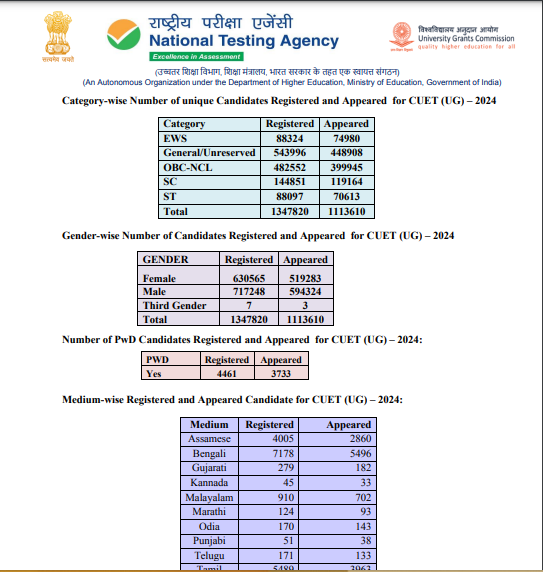
Latest syllabus of UGC NET for geography has been upoaded on websites of UGC(Univesity Grant Commission) and NTA(National Testing Agency). All aspirants must make preparation according to new syllabus . last update 25-04-2023

UGC NET GEOGRAPHY  Syllabus 2023 | NET GEOGRAPHY PAPER II SYLLABUS

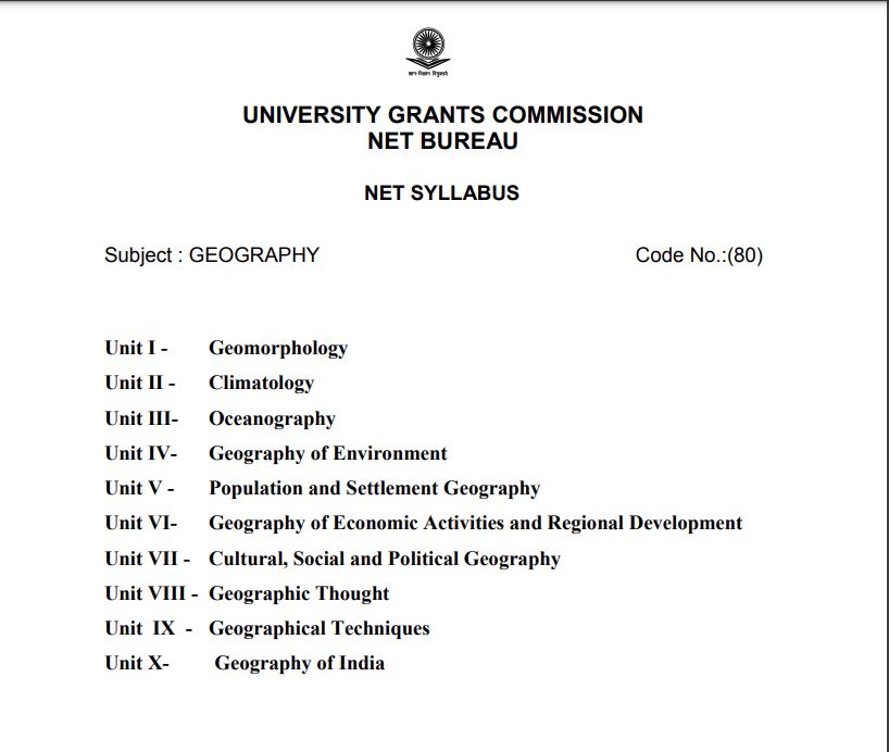
Paper II of Geography consists of 10 units which are

Unit I – Geomorphology

Unit II – Climatology

Unit III- Oceanography

Unit IV- Geography of Environment

Unit V – Population and Settlement Geography

Unit VI- Geography of Economic Activities and Regional Development

Unit VII – Cultural, Social and Political Geography

Unit VIII – Geographic Thought

Unit IX – Geographical Techniques

Unit X- Geography of India

UGC NET GEOGRAPHY  Syllabus 2023 | Detailed syllabus of Geography NET

UNIT-I Geomorphology

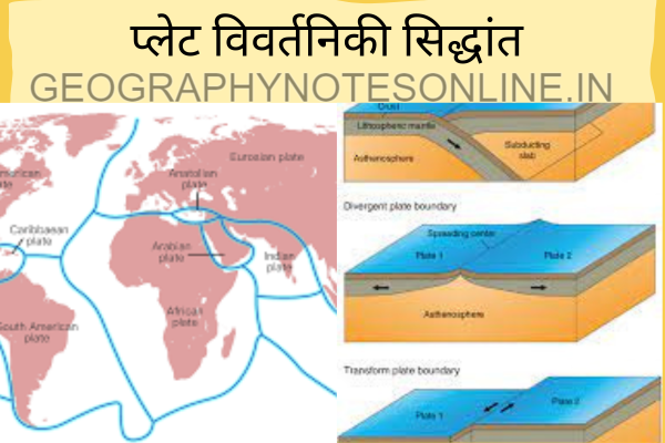
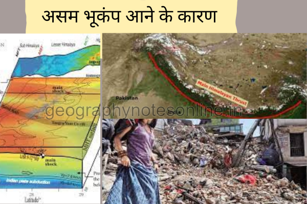
Continental Drift, Plate Tectonics, Endogenetic and Exogenetic forces. Denudation and Weathering, Geomorphic Cycle (Davis and Penck), Theories and Process of Slope Development, Earth Movements (seismicity, folding, faulting and vulcanicity), Landform Occurrence and Causes of Geomorphic Hazards (earthquakes, volcanoes, landslides and avalanches)

UNIT –II Climatology

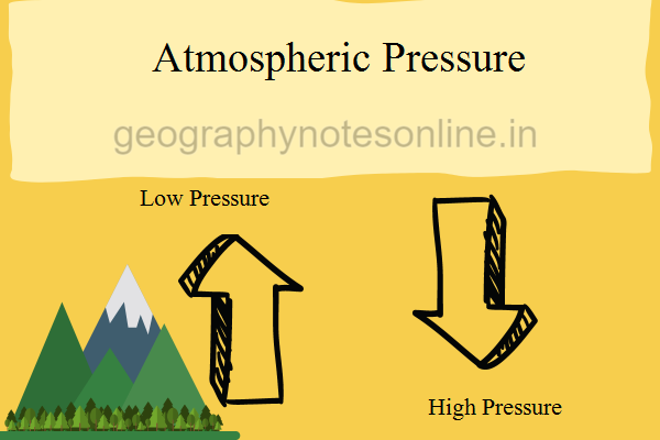
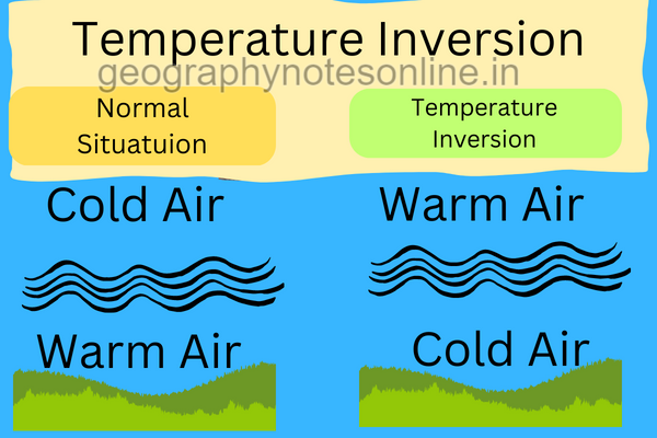
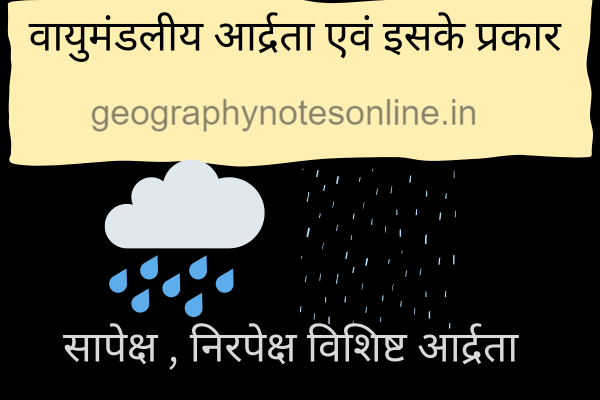
Composition and Structure of Atmosphere; Insolation, Heat Budget of Earth, Temperature, Pressure and Winds, Atmospheric Circulation (air-masses, fronts and upper air circulation, cyclones and anticyclones (tropical and temperate), Climatic Classification of Koppen & Thornthwaite, ENSO Events (El Nino, La Nina and Southern Oscillations), Meteorological Hazards and Disasters (Cyclones, Thunderstorms, Tornadoes, Hailstorms, Heat and Cold waves Drought and Cloudburst , Glacial Lake Outburst (GLOF), Climate Change: Evidences and Causes of Climatic Change in the past, Human impact on Global Climate.

UNIT-III Oceanography

 Relief of Oceans, Composition: Temperature, Density and Salinity, Circulation: Warm and Cold Currents, Waves, Tides, Sea Level Changes, Hazards: Tsunami and Cyclone

UNIT –IV Geography of Environment

Components: Ecosystem (Geographic Classification) and Human Ecology, Functions: Trophic Levels, Energy Flows, Cycles (geo-chemical, carbon, nitrogen and oxygen), Food Chain, Food Web and Ecological Pyramid, Human Interaction and Impacts, Environmental Ethics and Deep Ecology, Environmental Hazards and Disasters (Global Warming, Urban Heat Island, Atmospheric Pollution, Water Pollution, Land Degradation), National Programmes and Policies: Legal Framework, Environmental Policy, International Treaties, International Programmes and Polices (Brundtland Commission, Kyoto Protocol, Agenda 21, Sustainable Development Goals, Paris Agreement)

UNIT –V Population and Settlement Geography

Population Geography Sources of population data (census, sample surveys and vital statistics, data reliability and errors). World Population Distribution (measures, patterns and determinants), World Population Growth (prehistoric to modern period). Demographic Transition, Theories of Population Growth (Malthus, Sadler, and Ricardo). Fertility and Mortality Analysis (indices, determinants and world patterns). Migration (types, causes and consequences and models), Population Composition and Characteristics (age, sex, rural-urban, occupational structure and educational levels), Population Policies in Developed and Developing Countries. Settlement Geography Rural Settlements (types, patterns and distribution), Contemporary Problems of Rural Settlements ( rural-urban migration; land use changes; land acquisition and transactions), Theories of Origin of Towns (Gordon Childe, Henri Pirenne, Lewis Mumford), Characteristics and Processes of Urbanization in Developed and Developing Countries (factors of urban growth, trends of urbanisation, size, structure and functions of urban areas). Urban Systems ( the law of the primate city and rank size rule) Central Place Theories (Christaller and Losch), Internal Structure of the City, Models of Urban Land Use (Burgess, Harris and Ullman , and Hoyt), Concepts of Megacities, Global Cities and Edge Cities, Changing Urban Forms (peri-urban areas, rural-urban fringe, suburban , ring and satellite towns), Social Segregation in the City, Urban Social Area Analysis, Manifestation of Poverty in the City (slums, informal sector growth, crime and social exclusion).

Unit–VI: Geography of Economic Activities and Regional Development

Economic Geography Factors affecting spatial organisation of economic activities (primary, secondary, tertiary and quarternary), Natural Resources (classification, distribution and associated problems), Natural Resources Management. World Energy Crises in Developed and Developing Countries. Agricultural Geography Land capability classification and Land Use Planning, Cropping Pattern: Methods of delineating crop combination regions (Weaver, Doi and Rafiullah), Crop diversification, Von Thunen’s Model of Land Use Planning. Measurement and Determinants of Agricultural Productivity, Regional variations in Agricultural Productivity, Agricultural Systems of the World. Industrial Geography Classification of Industries, Factors of Industrial Location; Theories of Industrial Location (A. Weber, E. M. Hoover, August Losch, A. Pred and D. M. Smith). World Industrial Regions, Impact of Globalisation on manufacturing sector in Less Developed Countries, Tourism Industry, World distribution and growth of Information And Communication Technology (ICT) and Knowledge Production (Education and R & D) Industries. Geography of Transport and Trade Theories and Models of spatial interaction (Edward Ullman and M. E. Hurst) Measures and Indices of connectivity and accessibility; Spatial Flow Models: Gravity Model and its variants, World Trade Organisation, Globalisation and Liberalisation and World Trade Patterns. Problems and Prospects of Inter and Intra Regional Cooperation and Trade. Regional Development Typology of Regions, Formal and Fictional Regions, World Regional Disparities, Theories of Regional Development(Albert O. Hirschman, Gunnar Myrdal, John Friedman, Dependency theory of Underdevelopment, Global Economic Blocks, Regional Development and Social Movements in India

Unit – VII: Cultural, Social and Political Geography

Cultural and Social Geography Concept of Culture, Cultural Complexes, Areas and Region, Cultural Heritage, Cultural Ecology. Cultural Convergence, Social Structure and Processes, Social Well-being and Quality of Life, Social Exclusion, Spatial distribution of social groups in India (Tribe, Caste, Religion and Language), Environment and Human Health, Diseases Ecology, Nutritional Status (etiological conditions, classification and spatial and seasonal distributional patterns with special reference to India) Health Care Planning and Policies in India, Medical Tourism in India. Political Geography Boundaries and Frontiers (with special reference to India), Heartland and Rimland Theories. Trends and Developments in Political Geography, Geography of Federalism, Electoral Reforms in India, Determinants of Electoral Behaviour, Geopolitics of Climate Change, Geopolitics of World Resources, Geo-politics of India Ocean, Regional Organisations of Cooperation (SAARC, ASEAN, OPEC, EU). Neopolitics of World Natural Resources.

Unit VIII: Geographic Thought

Contributions of Greek, Roman, Arab, Chinese and Indian Scholars, Contributions of Geographers (Bernhardus Varenius, Immanuel Kant, Alexander von Humboldt, Carl Ritter, Scheafer & Hartshorne), Impact of Darwinian Theory on Geographical Thought. Contemporary trends in Indian Geography: Cartography, Thematic and Methodological contributions. Major Geographic Traditions (Earth Science, manenvironment relationship, area studies and spatial analysis), Dualisms in Geographic Studies (physical vs. human, regional vs. systematic, qualitative vs. quantitative, ideographic vs. nomothetic), Paradigm Shift, Perspectives in Geography (Positivism, Behaviouralism, Humanism, Structuralism, Feminism and Postmodernism).

Unit IX: Geographical Techniques

Sources of Geographic Information and Data (spatial and non-spatial), Types of Maps, Techniques of Map Making (Choropleth, Isarithmic, Dasymetric, Chorochromatic, Flow Maps) Data Representation on Maps (Pie diagrams, Bar diagrams and Line Graph, GIS Database (raster and vector data formats and attribute data formats). Functions of GIS (conversion, editing and analysis), Digital Elevation Model (DEM), Georeferencing (coordinate system and map projections and Datum), GIS Applications ( thematic cartography, spatial decision support system), Basics of Remote Sensing (Electromagnetic Spectrum, Sensors and Platforms, Resolution and Types, Elements of Air Photo and Satellite Image Interpretation and Photogrammetry), Types of Aerial Photographs, Digital Image Processing: Developments in Remote Sensing Technology and Big Data Sharing and its applications in Natural Resources Management in India, GPS Components (space, ground control and receiver segments) and Applications, Applications of Measures of Central Tendency, Dispersion and Inequalities, Sampling, Sampling Procedure and Hypothesis Testing (chi square test, t test, ANOVA), Time Series Analysis, Correlation and Regression Analysis, Measurement of Indices, Making Indicators Scale Free, Computation of Composite Index, Principal Component Analysis and Cluster Analysis, Morphometric Analysis: Ordering of Streams, Bifurcation Ratio, Drainage Density and Drainage Frequency, Basin Circularity Ratio and Form Factor, Profiles, Slope Analysis, Clinographic Curve, Hypsographic Curve and Altimetric Frequency Graph.

Unit – X: Geography of India

Major Physiographic Regions and their Characteristics; Drainage System (Himalayan and Peninsular), Climate: Seasonal Weather Characteristics, Climatic Divisions, Indian Monsoon (mechanism and characteristics), Jet Streams and Himalayan Cryosphere, Types and Distribution of Natural Resources: Soil, Vegetation, Water, Mineral and Marine Resources. Population Characteristics (spatial patterns of distribution), Growth and Composition (rural-urban, age, sex, occupational, educational, ethnic and religious), Determinants of Population, Population Policies in India, Agriculture ( Production, Productivity and Yield of Major Food Crops), Major Crop Regions, Regional Variations in Agricultural Development, Environmental, Technological and Institutional Factors affecting Indian Agriculture; Agro-Climatic Zones, Green Revolution, Food Security and Right to Food. Industrial Development since Independence, Industrial Regions and their characteristics, Industrial Policies in India. Development and Patterns of Transport Networks (railways, roadways, waterways, airways and pipelines), Internal and External Trade (trend, composition and directions), Regional Development Planning in India, Globalisation and its impact on Indian Economy, Natural Disasters in India (Earthquake, Drought, Flood, Cyclone, Tsunami, Himalayan Highland Hazards and Disasters.)


Also Read

Endogenic and Exogenic Forces

Endogenic and Exogenic Forces(Geography Notes) | अंतर्जात बल एवं बहिर्जात बल : पृथ्वी की स्थलरूप प्रक्रियाएँ और गतियां

स्थलरूप प्रक्रियाएँ पृथ्वी की सतह को आकार देने वाली विभिन्न गतियों और गतिविधियों का वर्णन करती हैं। इन प्रक्रियाओं को मुख्यतः दो वर्गों में बाँटा गया है: अंतर्जात और बहिर्जात प्रक्रियाएँ।

अंतर्जात प्रक्रियाएँ (Endogenic Processes)

यह प्रक्रियाएँ पृथ्वी के आंतरिक भाग से उत्पन्न होती हैं। इसमें मुख्यतः दो प्रकार की गतियाँ शामिल हैं:

1. विवर्तनिक गतियाँ (Diastrophism)

यह पृथ्वी की पर्पटी (क्रस्ट) की गति और विकृति से संबंधित है। इसमें दो प्रकार की गतियाँ आती हैं:

  • ओरोजेनी (Orogeny): पर्वत निर्माण की प्रक्रिया।
  • एपीरोजेनी (Epeirogeny): महाद्वीपों के उठने और गिरने की प्रक्रिया।

2. ज्वालामुखी गतिविधियाँ (Volcanism)

यह पृथ्वी की सतह पर लावा, गैसों और अन्य सामग्री का उत्सर्जन है, जो मुख्यतः ज्वालामुखियों से होता है।

बहिर्जात प्रक्रियाएँ (Exogenic Processes)

यह प्रक्रियाएँ बाहरी स्रोतों से ऊर्जा प्राप्त करती हैं और इनमें मुख्यतः निम्नलिखित प्रक्रियाएँ शामिल हैं:

1. अपक्षय (Weathering)

यह प्रक्रिया चट्टानों के टूटने और विघटन से संबंधित है। इसे तीन प्रकार में विभाजित किया जा सकता है:

  • भौतिक अपक्षय (Physical Weathering): चट्टानों का यांत्रिक टूटना।
  • रासायनिक अपक्षय (Chemical Weathering): चट्टानों का रासायनिक विघटन।
  • जैविक अपक्षय (Biological Weathering): पौधों और जीवों द्वारा चट्टानों का टूटना।

2. अपरदन (Erosion)

यह प्रक्रिया जल, वायु और बर्फ द्वारा सामग्री का हटाया जाना है।

3. परिवहन (Transportation)

यह प्रक्रिया अपक्षय और अपरदन से उत्पन्न सामग्री का एक स्थान से दूसरे स्थान तक स्थानांतरण है।

4. निक्षेपण (Deposition)

यह प्रक्रिया सामग्री के निचले स्थान पर जमा होने से संबंधित है।

इन प्रक्रियाओं का पृथ्वी की स्थलरूप संरचनाओं पर गहरा प्रभाव पड़ता है, जो समय के साथ लगातार परिवर्तित होती रहती हैं।

अन्य टॉपिक (Buy Online,Pdf Download) G C LEONG GEOGRAPHY BOOK 2023 | Certificate Physical and Human Geography written by Goh Cheng Leon

national parks and sancturies in rajasthan

National Park and Sancturies in Rajasthan | राजस्थान के राष्ट्रीय उद्यान और अभयारण्य

National Park and Sancturies in Rajasthan | राजस्थान के राष्ट्रीय उद्यान और अभयारण्य: राजस्थान, अपनी समृद्ध सांस्कृतिक विरासत के लिए प्रसिद्ध है, साथ ही भारत के कुछ सबसे विविध और जीवंत राष्ट्रीय उद्यानों और वन्यजीव अभयारण्यों का भी घर है। राज्य के अनूठे परिदृश्य, शुष्क रेगिस्तान से लेकर हरे-भरे जंगलों तक, वनस्पतियों और जीवों की एक विस्तृत विविधता के लिए एक आश्रय प्रदान करते हैं। यहाँ, हम राजस्थान के कुछ प्रमुख राष्ट्रीय उद्यानों और अभयारण्यों की खोज करेंगे।

National Park and Sancturies in Rajasthan: राष्ट्रीय उद्यान

  1. केवलादेव राष्ट्रीय उद्यान, भरतपुर
    28.73 वर्ग किलोमीटर में फैला, केवलादेव यूनेस्को की विश्व धरोहर स्थल है, जो अपनी पक्षी आबादी के लिए प्रसिद्ध है। यह पार्क पक्षी देखने वालों के लिए एक महत्वपूर्ण स्वर्ग है, जो हर साल हज़ारों प्रवासी पक्षियों को आकर्षित करता है।
  2. रणथंभौर राष्ट्रीय उद्यान, सवाई माधोपुर
    282.03 वर्ग किलोमीटर में फैला रणथंभौर भारत के सबसे लोकप्रिय राष्ट्रीय उद्यानों में से एक है, जो अपनी बाघ आबादी के लिए जाना जाता है। पार्क के सुरम्य खंडहर और हरे-भरे परिवेश इसे वन्यजीव प्रेमियों के लिए ज़रूर देखने लायक बनाते हैं।
  3. मुकुंदरा राष्ट्रीय उद्यान
    कोटा और चित्तौड़गढ़ में फैला मुकुंदरा अपने विविध पारिस्थितिकी तंत्रों के साथ एक शांत जगह प्रदान करता है। यह पार्क बड़े मुकुंदरा हिल्स टाइगर रिजर्व का हिस्सा है, जो बाघ संरक्षण पर जोर देता है।

National Park and Sancturies in Rajasthan : वन्यजीव अभयारण्य

  1. बांध बराठा वन्यजीव अभयारण्य, भरतपुर
    यह अभयारण्य 199.24 वर्ग किलोमीटर में फैला है और यहाँ कई तरह की वन्यजीव प्रजातियाँ रहती हैं, जो इस क्षेत्र की जैव विविधता के लिए एक महत्वपूर्ण आवास प्रदान करती हैं।
  2. रेगिस्तानी वन्यजीव अभयारण्य, जैसलमेर और बाड़मेर
    3,162 वर्ग किलोमीटर में फैला यह अभयारण्य अद्वितीय रेगिस्तानी पारिस्थितिकी तंत्र को दर्शाता है। यह भारतीय हिरन और रेगिस्तानी लोमड़ी सहित कठोर रेगिस्तानी परिस्थितियों के अनुकूल प्रजातियों का घर है।
  3. कुंभलगढ़ वन्यजीव अभयारण्य, उदयपुर, राजसमंद और पाली
    610.53 वर्ग किलोमीटर में फैला यह अभयारण्य ऐतिहासिक कुंभलगढ़ किले से घिरा हुआ है। यह अभयारण्य वनस्पतियों और जीवों से समृद्ध है, जिसमें दुर्लभ और मायावी तेंदुआ भी शामिल है।
  4. सरिस्का वन्यजीव अभयारण्य, अलवर
    492.29 वर्ग किलोमीटर में फैला सरिस्का राजस्थान का एक और प्रमुख बाघ अभयारण्य है। अभयारण्य के विविध परिदृश्य और ऐतिहासिक खंडहर इसके आकर्षण को बढ़ाते हैं।
  5. माउंट आबू वन्यजीव अभयारण्य, सिरोही
    326.10 वर्ग किलोमीटर में फैला यह अभयारण्य अरावली पर्वतमाला में स्थित है। यह अपनी समृद्ध जैव विविधता के लिए जाना जाता है और इस क्षेत्र की कई अनूठी वनस्पतियों और जानवरों की प्रजातियों के लिए एक आश्रय स्थल है।
S.NoName of National Parks/ Wild Life SanctuaryDistrictArea(Sq.km.)
   National Parks
1Keoladeo National ParkBharatpur28.73
2Ranthambore National ParkSawai Madhopur282.03
3Mukundara National ParkKota, Chittorgarh 
  Sub Total310.76
    Sanctuaries
1Bandh Baratha WL SanctuaryBharatpur199.24
2Bassi WL SanctuaryChittorgarh138.69
3Bhensrodgarh WL SanctuaryChittorgarh201.40
4Darrah Game SanctuaryKota, Jhalawar239.76
5Desert WL SanctuaryBarmer, Jaisalmer3,162.00
6Fulwari ki Nal WL SanctuaryUdaipur511.41
7Jaisamand WL SanctuaryUdaipur52.34
8Jamwa Ramgarh WL SanctuaryJaipur300.00
9Jawahar Sagar WL SanctuaryKota,Bundi,Chittorgarh220.09
10Keladevi WL SanctuaryKaroli,Sawai Madhopur676.82
11Kesarbagh WL SanctuaryDholpur14.76
12Kumbalgarh WL SanctuaryUdaipur,Rajsamand,Pali610.53
13Mount Abu WL SanctuarySirohi326.10
14Nahargarh WL SanctuaryJaipur52.40
15National Chambal WL SanctuaryKota, S.Madhopur, Bundi, Dholpur, Karauli280.00
16Ramgarh Vishdhari WL SanctuaryBundi307.00
17Ramsagar WL SanctuaryDholpur34.40
18Sajjangarh WL SanctuaryUdaipur5.19
19Sariska WL SanctuaryAlwar492.29
19 (A)Sariska  ‘A’ WL SanctuaryAlwar3.01
20Sawai Manshingh WL SanctuarySawai Madhopur113.07
21Shergarh WL SanctuaryBaran81.67
22Sitamata WL SanctuaryChittorgarh,Udaipur422.94
23Tal Chappar WL SanctuaryChuru7.19
24Todagarh Rawali WLSanctuaryAjmer,Pali,Rajsamand475.24
25Van Vihar WL SanctuaryDholpur25.60
26Sawai Madhopur SanctuarySawai Madhopur131.30
  Sub Total9084.44
  Grand Total9395.20

Source: Rajasthan Forest Statistics 2017.

Read More- Rajasthan Ecotourism Policy 2021 | राजस्थान ईको टूरिज्म पाॅलिसी 2021

संरक्षण के प्रयास

संरक्षण के प्रति राजस्थान की प्रतिबद्धता इसके संरक्षित क्षेत्रों के व्यापक नेटवर्क के माध्यम से स्पष्ट है। ये पार्क और अभयारण्य राज्य की प्राकृतिक विरासत को संरक्षित करने और कई प्रजातियों के अस्तित्व को सुनिश्चित करने में महत्वपूर्ण भूमिका निभाते हैं। इन क्षेत्रों के संरक्षण और प्रबंधन को बढ़ाने, सतत पर्यटन और वन्यजीव संरक्षण को बढ़ावा देने के लिए लगातार प्रयास किए जाते हैं।

निष्कर्ष

राजस्थान के राष्ट्रीय उद्यान और अभयारण्य राज्य की समृद्ध प्राकृतिक सुंदरता और जैव विविधता की झलक पेश करते हैं। भरतपुर में पक्षी देखने वालों के आनंद से लेकर रणथंभौर के राजसी बाघों तक, ये संरक्षित क्षेत्र राजस्थान के अपने वन्यजीवों के संरक्षण के प्रति समर्पण के प्रमाण हैं। चाहे आप एक उत्साही प्रकृति प्रेमी हों या बस एक शांत छुट्टी की तलाश में हों, ये पार्क और अभयारण्य एक अविस्मरणीय अनुभव प्रदान करते हैं।

अधिक जानकारी के लिए, आप राजस्थान वन विभाग की वेबसाइट पर जा सकते हैं।